Showing posts with label Utah. Show all posts

Wednesday, January 9, 2013

Escape from Civiliazation: Valley of the Gods

If you want to escape from civilization, look no further. Valley of the Gods, mere 40 miles north-east of the world-famous, tourist-infested Monument Valley, has no crowds, no cell-phone or radio reception, no paved roads, no restrooms and/or any other facilities, yet by many it's considered to be more spectacular than its aforementioned famous cousin.


We spent two hours there and saw only one other car somewhere in distance. What a stark contrast to Monument Valley, where you see at least five cars at each single viewpoint or turn of the road. Additionally, there is no fee to enter Valley of Gods, and you're welcome to do there whatever pleases you: you can camp there (again for free), go hiking anywhere you want, or even do some bouldering/rope climbing. Valley of the Gods is yours to play with.


Similar to Monument Valley, the most prominent rocks in the Valley of the Gods have names. These names are typically meant to describe what the rock formation resembles, so for example in the Valley of the Gods you can Setting Hen Butte, Lady in the Tub, Battleship and Seven Sailors. It's actually lots of fun to try to look for those shapes in the rocks.

On the left: Lady in a Tub


There's only one road leading through the park: a bumpy 17-mile-long dirt and gravel road with many steep sections and sharp turns. As I'm a road, not destination, kind of person, I had lots of fun driving there and I loved that each bend in the road hold a surprise: a new rock formation or a new scenery.


The best time to visit the Valley of the Gods is in late afternoon, when the sun is low and the rocks glow in beautiful warm red color.

On the left: Setting Hen Butte


Sunset is a great time too, as it emphasizes the ruggedness of the landscape.


Tuesday, January 8, 2013

Goosenecks State Park

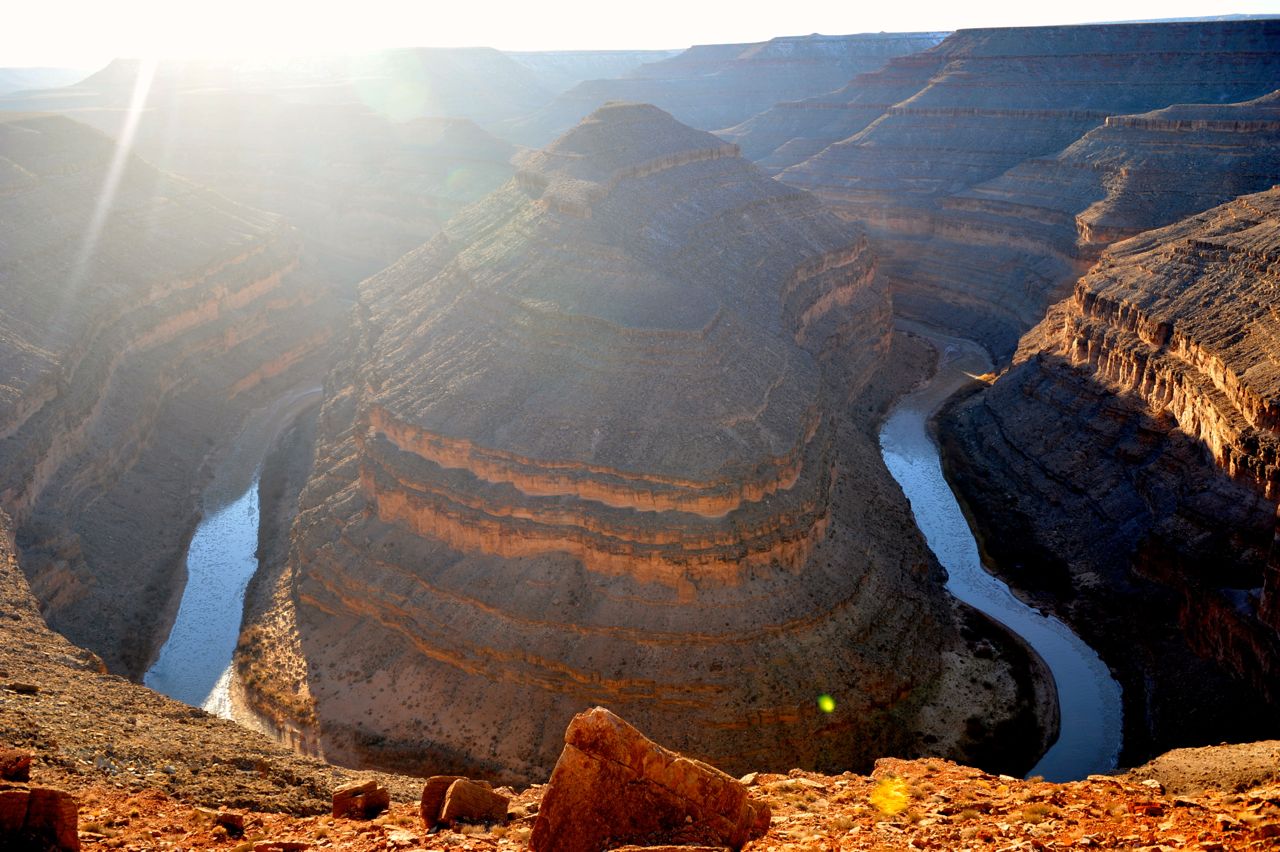
Goosenecks State Park offers a one-of-a-kind scenic view of the meandering San Juan River and the deep canyon painstakingly cut by the river over thousands of years.


Near the viewpoint, the river makes a series of tight turns–goosenecks–which give the park its name.


The viewpoint is located about 1'000 feet above the river and offers a simultaneous view of three of the San Juan River goosenecks. However, even my wide-angle lens wasn't able to fit all of them in one photo. So I'm leaving this to your imagination, or encourage you to visit Goosenecks State Park yourself.


There are no hiking trails in the park and its sole purpose of existence seem to be to provide the views of the river, yet it's worth seeing at least once in your life.


However, if you go there, learn from my mistake and visit the park in the morning or during the midday, as in the late afternoon the sun shines directly above the goosenecks, making photography almost impossible.

Sunday, January 6, 2013

Fascinating Nature: American South-West in a Winter Robe

I have traveled many times through the American South-West, but this last trip was my first winter trip to the region.

To my great surprise, winter appears to be a great time to visit the South-West, possibly better than any other season. The key reason behind that is that tourists seem not to like cold weather and, subsequently, there were hardly any of them in most places we visited (with a small but notable exception of Grand Canyon, which is popular year-round).


The lack of tourists translates to a better overall experience, as witnessing the beauty and splendor of the South-West in solitude is bound to enhance your appreciation of the forces that stand behind the creation of this world's most amazing natural wonder.

Solitude encourages contemplation, introspection, as well as it enhances senses and brings closer the examiner and the subject of examination. In my case, it also led to a realization that American South-West is a Playground of Nature, a place where Nature experimented with all possible rock shapes and forms, before deciding how the rest of Earth should look like.

My second big realization was that this Nature's Playground is My Playground too. I've been very fortunate to be able to travel multiple times through South-West, with time getting to know it as well as my own backyard. This growing intimate knowledge of the region allows me to probe it further and deeper with each subsequent visit, leading to even deeper fascination and admiration for the Nature and its ways.

During the next few weeks I'm going to blog about my favorite places in the South-West, and the way they look during winter.

Here's a list of places I'll rave about:
  1. Valley of Fire State Park
  2. Monument Valley Tribal Park
  3. Gooseneck State Park
  4. Valley of Gods
  5. Canyonlands National Park, The Needless Area
  6. Newspaper Rock State Park
  7. Arches National Park
  8. Canyonlands National Park, Island in the Sky Area
  9. Dead Horse Point State Park
  10. Goblin Valley State Park
  11. Colorado National Monument
  12. Hovenweep National Monument
  13. Valley of the Ancients National Monument
  14. Mesa Verde National Park
  15. Aztec National Monument
  16. Chaco Culture National Historic Park
  17. Grand Canyon National Park, South Rim
  18. Rainbow Bridge National Monument
  19. Vermillion Cliffs National Monument
  20. Grand Staircase Escalante National Monument
  21. Paria Canyon-Vermilion Cliffs Wilderness
  22. Bryce National Park
  23. Kodachrome State Park
  24. Pink Sand Dunes State Park
  25. Zion National Park

Tuesday, December 7, 2010

Roadtrip 2008: Peek-A-Boo Trail in Bryce NP

On the second day of our stay in Bryce NP we went for a 7-mile long hike into the canyon. We started the hike at Bryce Point with the Peek-A-Boo Trail, which drops quickly to the canyon floor and is not heavily used neither by hikers nor mules. Because of those two reasons it is my favorite hike in Bryce.

If you want to make it even better, I would recommend combining it with the spectacular Queens Garden Trail, as we did.

A few pictures from the hike:


Sunday, December 5, 2010

Road Trip 2008: Bryce NP

Bryce NP was the last national park that Agnieszka and I visited during our two week-long road trip through the Southwest in 2008. I had been to Bryce already in 2006, but for Agnieszka it was the first time. She was so immensely impressed with it that she said that she was glad it was the very last place we visited, as all other parks would seem unimpressive compared to it.

The first thing that we did in the park was to go for a drive to Rainbow Point (18 miles one way). There are 13 viewpoints along the road and we stopped at all of them. I think Rainbow and Bryce Points offered the best views, but the photos below should help you judge that for yourself.

Rainbow Point:


Natural Bridge


Bryce Point


Sunrise Point

Wednesday, December 1, 2010

Road Trip 2008: Canyonlands NP

Agnieszka and I had only one day to explore Canyonlands NP and I would say that's precisely how much time you need there if you plan to visit only the main part (called Island in the Sky) of the park. However, if you would like to venture into the Needles District, you will need both more time and a four-wheel-drive (or be willing to backpack for a few days).

"Island in the Sky" is located just 30 miles away from Arches NP, so the two parks can be easily visited during the same trip. Compared with Arches, Canyonlands does not seem too impressive, at least on the surface. I am sure though that it is a much better place for backpacking than Arches.

Upheaval Dome:


Agnieszka:


Green River Overlook:


Grand View Point:


Mesa Arch:

Monday, November 29, 2010

Road Trip 2008: Arches NP

Arches NP preserves over 2000 natural sandstone arches. The most famous one is Delicate Arch, to which I dedicated a separate post. But the park is also home to many other interesting rock formations that can easily ignite imagination not only of photographers.

There is only one small campground in the park, so it fills up very quickly. As we really wanted to stay within the park, to make sure it would happen, we got to the park at around 6 am... And even though we were there so early, there were already several other people in line in front of us. Luckily, the early bird catches the worm, and so did we manage to get one of the campsites.

We spent two days and two nights in the park, which seems to be just enough to see most of it (unless you plan to go backpacking). During that time we went for two longer and several shorter hikes. Descriptions of the shorter hikes you can find below, and to the longer ones I dedicated separate posts.

The Balanced Rock Trail is a short (0.3 mile) loop hike up to, and around, the Balanced Rock. It is definitely fascinating to see this balancing act of Nature:


The trail leading to the Park Avenue area is 1 mile long (one way) and leads next to several interesting rock formations. My favorite was the rock that Agnieszka and I called "Pharoah" (I think the official name of the rock is "Queen Nefertiti"):


Park Avenue, Courthouse Towers:


Petrified Dunes, La Sal Mountains in the background:


Garden of Eden, La Sal Mountains:


The hike to North and South Window is 1 mile (1.6 km) long and takes around 40 minutes:

Saturday, November 27, 2010

Roadtrip 2008: Delicate Arch in Arches NP

Delicate Arch is the most widely recognized landmark of both Arches NP and Utah. Its delicate beauty inspired millions of amateur, as well as professional, photographers from all over the world. It was featured multiple times on magazine covers and it is also depicted on Utah license plates.

The best way to see it is to go on a 1.5 mile long (one way) hike that starts at Wolfe Ranch parking area. The hike is very pleasant even though you can not see the Arch until the very last 100 meters of the trail.

This hike is not wheel-chair accessible. But luckily, the Arch can also be seen from a viewpoint (Lower Delicate Arch Viewpoint) that is located just next to the parking lot. From there you can see the Arch at a distance of about one mile and to take a good picture of it you will need a telephoto lens and a tripod.

From the Lower Delicate Arch Viewpoint you can continue for another 0.5 mile to the Upper Delicate Arch Viewpoint, which is closer to the Arch. However, the views from there are basically the same as from the Lower Viewpoint (though the need for a tele lens and tripod disappears).

We visited the Lower and Upper Viewpoints early in the morning, but we decided to hike to the base of Delicate Arch around sunset as this is the best time to see it. For around 5 minutes the color of the Arch is changing from yellow-orange into beautiful deep warm orange-red. It's definitely worth seeing this transformation, even though, literally, you will share this experience with several hundred other hikers and/or photographers... It did feel very artificial and surreal to be waiting with so many other people for the moment that each of us wished to be intimate.

Delicate Arch, early morning, view from the Lower Delicate Arch Viewpoint:


Delicate Arch, early morning, view from the Upper Delicate Arch Viewpoint:


Our shadows on the trail to Delicate Arch:


Hundreds of amateur photographers waiting for the sunset at Delicate Arch:


Delicate Arch, 45 minutes before sunset, the warm sunset light is not quite there yet:


Delicate Arch, 25 minutes before sunset, the long-awaited 4 minutes of warm light finally arrived: