Monday, November 29, 2010

Road Trip 2008: Arches NP

Arches NP preserves over 2000 natural sandstone arches. The most famous one is Delicate Arch, to which I dedicated a separate post. But the park is also home to many other interesting rock formations that can easily ignite imagination not only of photographers.

There is only one small campground in the park, so it fills up very quickly. As we really wanted to stay within the park, to make sure it would happen, we got to the park at around 6 am... And even though we were there so early, there were already several other people in line in front of us. Luckily, the early bird catches the worm, and so did we manage to get one of the campsites.

We spent two days and two nights in the park, which seems to be just enough to see most of it (unless you plan to go backpacking). During that time we went for two longer and several shorter hikes. Descriptions of the shorter hikes you can find below, and to the longer ones I dedicated separate posts.

The Balanced Rock Trail is a short (0.3 mile) loop hike up to, and around, the Balanced Rock. It is definitely fascinating to see this balancing act of Nature:


The trail leading to the Park Avenue area is 1 mile long (one way) and leads next to several interesting rock formations. My favorite was the rock that Agnieszka and I called "Pharoah" (I think the official name of the rock is "Queen Nefertiti"):


Park Avenue, Courthouse Towers:


Petrified Dunes, La Sal Mountains in the background:


Garden of Eden, La Sal Mountains:


The hike to North and South Window is 1 mile (1.6 km) long and takes around 40 minutes:

Saturday, November 27, 2010

Roadtrip 2008: Delicate Arch in Arches NP

Delicate Arch is the most widely recognized landmark of both Arches NP and Utah. Its delicate beauty inspired millions of amateur, as well as professional, photographers from all over the world. It was featured multiple times on magazine covers and it is also depicted on Utah license plates.

The best way to see it is to go on a 1.5 mile long (one way) hike that starts at Wolfe Ranch parking area. The hike is very pleasant even though you can not see the Arch until the very last 100 meters of the trail.

This hike is not wheel-chair accessible. But luckily, the Arch can also be seen from a viewpoint (Lower Delicate Arch Viewpoint) that is located just next to the parking lot. From there you can see the Arch at a distance of about one mile and to take a good picture of it you will need a telephoto lens and a tripod.

From the Lower Delicate Arch Viewpoint you can continue for another 0.5 mile to the Upper Delicate Arch Viewpoint, which is closer to the Arch. However, the views from there are basically the same as from the Lower Viewpoint (though the need for a tele lens and tripod disappears).

We visited the Lower and Upper Viewpoints early in the morning, but we decided to hike to the base of Delicate Arch around sunset as this is the best time to see it. For around 5 minutes the color of the Arch is changing from yellow-orange into beautiful deep warm orange-red. It's definitely worth seeing this transformation, even though, literally, you will share this experience with several hundred other hikers and/or photographers... It did feel very artificial and surreal to be waiting with so many other people for the moment that each of us wished to be intimate.

Delicate Arch, early morning, view from the Lower Delicate Arch Viewpoint:


Delicate Arch, early morning, view from the Upper Delicate Arch Viewpoint:


Our shadows on the trail to Delicate Arch:


Hundreds of amateur photographers waiting for the sunset at Delicate Arch:


Delicate Arch, 45 minutes before sunset, the warm sunset light is not quite there yet:


Delicate Arch, 25 minutes before sunset, the long-awaited 4 minutes of warm light finally arrived:

Thursday, November 25, 2010

Roadtrip 2008: Devils Garden Primitive Loop in Arches NP

At the end of the 18-mile long road leading through the park is the trailhead of the Devils Garden Primitive Loop. At 7.2 miles (11.5 km) it is the longest maintained trail in the park. It leads to several beautiful arches: Landscape, Tunnel, Pine Tree, Wall, Double O, Partition and Navajo. The first part of the trail is paved, level, and wide. But once you pass Landscape Arch, the trail gets rougher and at times difficult to find.

The highlight of the trail is Landscape Arch, which is the longest natural arch in the world, measuring 290 feet (88.4 m). Unfortunately, likely the arch will collapse some time soon. In the last several years three pieces of sandstone have fallen from its thinnest section, forcing the park to close the trail that once passed under it. I am definitely glad that I had a chance to see it while it still stands in all its glory.

Also other arches along the trail are worth seeing and I would definitely highly recommend this hike.

Landscape Arch:


Navajo Arch:


Pine Tree Arch:


Picnic at Dark Angel:


Other interesting rock formations along the trail:


Double O Arch (on the photo is lower O arch):


View to the Dark Angel Pinnacle through Double O Arch:

Tuesday, November 23, 2010

Dipsea Trail - Mill Valley to Stinson Beach

Last Saturday we hiked the full length of the Dipsea Trail, all the way from Mill Valley to Stinson Beach, and back.

Total distance hiked: 14.8 miles (23.82 km)
Elevation change: 9,276 feet (2,827 m)

As I realized after the hike, that's almost exactly the same distance and elevation change that one has to hike when going to the bottom of the Grand Canyon and back. The more proud I am to report that we completed the hike in 6h 30 min!

Since I did not find a good description of this hike anywhere in the internet, I am going to try to be as detailed in my description as possible.

The trailhead for the Dipsea Trail is located in Old Mill Park in Mill Valley, CA (for directions click here).

There are several (free) parking spots in the Old Mill Park along Cascade Drive. Try to park as close to the park entrance as possible, as the trailhead is located just opposite the entrance at the intersection of three roads: Cascade Drive, Cascade Way, and Molino. There are no obvious trail markings and it almost looks like the trail leads to somebody's house: take a look at Google Map street view. Don't get discouraged by that and aim for the staircase located in the driveway on the photo above.

The trail starts with three flights of stairs (adding up to 671 steps). According to the local legend, people who hiked and/or run Dipsea never die, they just reach the 672nd step :)

Once you walked up the first set of stairs, you will need to take a few steps to the right. The second set of stairs will be there. To find the third set, you will need to take a few steps to the left.

After the third set of steps you will find yourself on Sequoia Road. Follow the road (to the west/right) for around 600 ft (200 m), until you get to Walsh Drive. Continue on Walsh Drive and then Bay View until you reach Panoramic Highway. This is where you finally get off the pavement and where the good trail markings start.

The trail will continue on the other side of the highway, slightly to the right of the direction from which you came from. After around 5 minutes the trail will reach Muir Woods Road and will run parallel to it for around 0.4 mile (0.6 km). (In November 2010, this part of the trail was closed due to a mudslide. It's not a big deal, as you can walk on the road and rejoin the proper trail after 0.4 mile. To find the continuation of the Dipsea Trail, look for a sign "Cam Del Canon" and a few mailboxes on the left side of the road. It is so obvious that you can not miss it.)

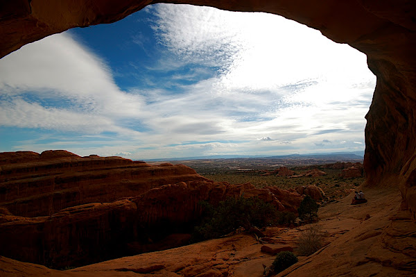
Starting at Panoramic Highway the trail steadily drops down ~700 feet (210 m), until it reaches the lower parking lot of Muir Woods. From there, over the course of 2.2 miles (3.5 km), you will need to climb ~1400 feet (430 m), until you get to the top of "Cardiac Hill". As the name suggests, "Cardiac Hill" can make your heart start pumping pretty hard, but the views from there are absolutely fantastic and will fully compensate for your climbing efforts. On a clear day you will be able to see San Francisco, the Bay Bridge, Oakland, top of the Golden Gate Bridge, the Bay and the Pacific Ocean.

If you feel tired and did not arrange for anybody to pick you up at the end of the trail in Stinson Beach, this would be a good place to turn around, as from here over the course of next 3 miles (4.8 km), the trail will drop all the way down to the ocean, and you will loose all the elevation that you gained so far. But if you feel strong, I would definitely recommend going all the way to Stinson Beach, as this part of the hike is the prettiest. From now on, the trail will lead you through a deep misty forest across several Marin hills. Moreover, during the final one mile of the trail there are spectacular views of Stinson Beach and the ocean.

After reaching Stinson Beach you have a choice of either going back the same way you came (this is what we did last Saturday), or you can make your hike even longer by first hiking the Matt Davis & Steep Ravine Trails (described here and here) before rejoining the Dipsea Trail.

All in all this is a fantastic, but challenging hike. It crosses several parks: Mt. Tamalpais SP, Muir Woods NM, the Golden Gate Recreational Area, and it brings you all the way to the ocean and a nice beach. It should not be attempted by novice hikers (unless you do it one-way only). Depending on your strength, it can take you anything from 5 to 8 (or more) hours to complete it. Though there are people who run it in 2h...

For us, the first half of the hike (getting to Stinson Beach) was super-easy and fast, but hiking back from there was not. I started feeling pain in one of my knees at around mile 11 and, therefore, the last 4 miles where a bit unpleasant - especially during the downhills. Absolute killer for me was at the end of the hike when we had to walk down the 671 steps... Every single one of them was hurting.

At around mile 14, Anil renamed the hike "Dip-shit", which expresses pretty well what we felt at that particular moment... Still, we are very proud of ourselves for having finished it and we are surprised that today, a day later, nothing hurts us. I hope that it means that both of us are in a reasonably good shape before our Andean adventure.

The hike begins with 671 steps:

The second half of the trail leads through the beautiful green forest of Muir Woods NM:


The views from the top of Cardiac Hill:


Just a mile away from Stinson Beach:


And finally we reached the beach!

Monday, November 22, 2010

Diwali

Last Saturday Anil and I went to his family's friends to celebrate Diwali, also known as festival of lights. It is the most important festival for Hindus. It commemorates the return of Lord Rama from the fourteen-year-long exile and vanquishing the demon-king Ravana. Diwali is very popular with children as part of the celebration includes bursting firecrackers :)

My niece, Aditi, with a firework:

My nephew, Ram, lightning his firework:

Important part of any Indian gathering: food!

Let's put toys on Auntie Monika's head!

More fireworks:

Sparks between my husband and I:

Saturday, November 20, 2010

Honeymoon Road Trip

I'm very happy and proud to report that I finally managed to finish all posts describing our honeymoon adventures!

Below they are listed in the chronological order:
  1. Honeymoon
  2. Honeymoon Overview
  3. Death Valley NP - Darwin Falls Hike
  4. Death Valley NP - Mosaic Canyon Hike
  5. Death Valley NP - Mesquite Flat Sand Dunes
  6. Death Valley NP - Devil's Golfcourse
  7. Death Valley NP - Zabriskie Point
  8. Death Valley NP - Dante's View
  9. Death Valley NP - Artist's Drive and Palette
  10. Death Valley NP - Badwater Basin
  11. Snow in Death Valley
  12. Grand Canyon NP - Grandview Trail
  13. "For the record, I am dying..." - Hiking on the Grandview Trail in Grand Canyon
  14. Grand Canyon NP - Viewpoints
  15. Petrified Forrest NP - Giant Logs Trail
  16. Petrified Forrest NP - Crystal Forest
  17. Petrified Forrest NP - Newspaper Rock
  18. Petrified Forrest NP - Painted Desert
  19. Route 66
  20. On the Way to Chaco Canyon NM
  21. Rio Grande Overlook
  22. Bandalier NM
  23. Los Alamos - Bradbury Science Museum
  24. Kasha-Katuwe NM
  25. Great Sand Dunes NP - The High Dune Hike
  26. Great Sand Dunes NP - Dunes Overlook + Medano Creek Hike
  27. Great Sand Dunes NP - Sunset
  28. Zapata Falls
  29. City of Taos and Taos Pueblo
  30. Santa Fe
  31. El Santuario de Chimayo
  32. Roswell - Extraterrestrial Hwy 285 and the City
  33. Roswell - International UFO Museum and Research Center
  34. Carlsbad Caverns NP - The Natural Entrance and the Big Room
  35. Carlsbad Caverns NP - King's Palace
  36. Carlsbad Caverns NP - Bat Flight Program
  37. Carlsbad Caverns NP - Desert
  38. Guadalupe Mountains NP - McKittrick Canyon Hike
  39. Change of Plans
  40. Alamogordo - Museum of Space History
  41. White Sand Dunes
  42. Lower Antelope Canyon
  43. Lake Powell and Glen Canyon Dam
  44. Bryce - Fairyland Trail
  45. Bryce - Queen's Garden & Navajo Trail Loop
  46. Bryce NP - Viewpoints
  47. Mojave Desert
  48. Joshua Tree - Lost Palm Oasis Hike
  49. Joshua Tree - Cholla Garden
  50. Joshua Tree - Skull Rock Hike
  51. Joshua Tree - Arch Rock Hike
  52. Joshua Tree - Keys View
  53. Joshua Tree - Indian Cove Nature Walk
  54. Joshua Tree - 49 Palm Oasis Hike
  55. Santa Monica
  56. Santa Barbara

Friday, November 19, 2010

Kiva Groupon

Friends, till Sunday evening for $15, you can get a $25 Kiva.org microloan credit to help fund the low-income entrepreneurs in the developing world. 

The deal is on Groupon.

Thursday, November 18, 2010

Bryce NP - Queen's Garden & Navajo Trail Loop

The Fairyland Loop Trail left us wanting to see more of the park, so after a short break we set out for another hike. This time into the Bryce Amphitheater.

We started the hike at Sunrise Point with the Queen's Garden Trail, which is the least steep trail entering the canyon. It is also one of the prettiest trails in the park as it passes next to some of the most interesting hoodoos and several natural bridges.

The Queen's Garden Trail connects with the Navajo Trail, which we used to hike out of the canyon. The last part of the trail is very steep. It leads through a slot canyon called "Wall Street" to Sunset Point, where the trail ends. To complete the loop and get back to your car, you will need to hike another 0.3 mile on the Rim Trail.

The combined trails create a 2.9 mile (4.6 km) loop with the elevation change of 580 ft (177 m), which modestly is called in the park's newsletter "the prettiest 3-mile hike in the world". Well, they might just be right about this one.

Queen's Garden:


One of several bridges:


On the trail:


Honeymoon picture :)


Wall Street:


Some of the best views in Bryce NP are on the trail under the rim near Sunset Point: