Wednesday, July 17, 2013

Alaska, Here We Come!

This is one busy summer. Less than a week ago we came back from a three-week-long trip to Yellowstone and surrounding national parks, and today we're flying to Alaska for two weeks.

Badlands National Park - One of the Highlights of the "Yellowstone Trip"


I sincerely hope Alaska will be as beautiful and intriguing as I imagine, as I've never had to work so hard to plan any other trip as this one. Planning the trip to Alaska took a lot of time because of two key reasons: (1) Not many places in Alaska can be reached by roads, hence the need to prearrange other forms of transport like small planes and/or boats; (2) Not many businesses in Alaska have good websites and online reservation systems, which meant that I needed to spend many hours on the phone calling one business after the other.

But now the planning phase is over and it's time to sit back, relax, and enjoy the new frontier :)


Saturday, April 20, 2013

Alamere Falls

One of my favorite waterfalls in the Bay Area is Alamere Falls, by some considered to be in top ten most beautiful waterfalls in the world.

What makes Alamere Falls unique is that it flows directly into the ocean. Moreover, it can only be accessed by a relatively long hike (4 miles one-way), which means that usually you can enjoy the beauty of the falls and surrounding them beach in solitude. A truly perfect spot for a relaxing picnic, a walk along the beach, a dip in the ocean, or a nap.

Alamere Falls flows directly into Pacific


Showering in Love :)


Horse-riding on the beach near the falls

The Upper Cascades of the Alamere Falls

The Upper Cascades of the Alamere Falls

Saturday, April 13, 2013

Self-portraits with Waterfalls

I have followed my own advice from the previous post and this weekend I spent exploring several waterfalls of Whiskeytown/Mt. Shasta area. During last three days we hiked over 30 miles and saw over ten waterfalls–all of which were amazing. We definitely are going to come back here for more waterfall hiking. In meantime, we have to be satisfied with the few waterfalls we saw and memories of them captured on film.

Hedge Creek Falls

Upper Brandy Creek Falls

Crystal Creek Falls

Testing our new car on the way to Whitney Falls (test passed)

Middle McCloud Falls


Tuesday, April 9, 2013

Waterfalls of California

There are many reasons why I've been terribly inconsistent in my blogging. The key one is that I'm trying to travel as much as possible this year, and in between travels I'm preoccupied planning the next adventure.

The plans for this year are very ambitious. In a week I'll be going to Europe for a month, where I plan to visit Estonia, Latvia, Belarus, Poland and Germany. Soon after that trip, I'll be going to Rocky Mountain and West North Central States for three weeks, where I plan to photograph nine national parks that I haven't visited before. As soon as that trip is over, I'll be flying to Alaska for more national parks and wildlife photography. And the culmination of my summer will be also its highlight: backpacking the southern half of John Muir Trail.

After that last trip, I hope to be able to slow down a bit, so that I can have time to process all the photographs accumulating on my laptop, as well as to work on some personal goals that require me to stay put rather than sleep five nights a week in a hotel.

Anyway, the purpose of this blog post is to let all my California friends know that the weather is perfect right now to go hiking on one of many waterfall trails that we have scattered all over the Bay Area and other parts of California. With the snow starting to melt in the mountains and recent rains, all the waterfalls are at their peak, waiting for you to pay them a visit. Don't disappoint them!

If you want my personal recommendation, the Cataract Falls Trail would be it. Take a look at the photos below to see how spectacular it looked just five days ago. Enjoy and let me know if you find some other great waterfall trails that I might not know about.


Sunday, March 3, 2013

Road Closed. Nature Vs. Humans 1:0

The wise John Muir once wrote "The world, we are told, was made especially for man — a presumption not supported by all the facts" (from A Thousand-Mile Walk To the Gulf).

This truth becomes especially evident at the end of Chain of Craters Road, in Volcanic National Park on Big Island in Hawaii. There, one can witness first-hand that it is Nature that sets the rules for our existence on Earth, not the other way around.


Just few years after it was build, the coastal portion of Chain of Craters Road was destroyed–along with many houses, ancient Hawaiian sites and the Volcano National Park visitor center–by a lava flow from  the Puʻu ʻŌʻō vent of the Kilauea volcano.


Despite the destruction, something beautiful was created–Nature's Museum of Modern Art, with thousands of unique forms and shapes of solidified lava. But more about it in the next post.

Friday, March 1, 2013

Fuming Volcano

To Anil the highlight of our trip to Big Island was the night swim with Manta Rays. To me it was seeing an active volcano. The most active volcano on Earth, in fact, Kilauea, which current eruption has started over 30 years ago, in January of 1983.

During the day, when the sun is high above the horizon, the volcano doesn't look very impressive or scary. Then it's simply a giant hole with a bit of white fume coming out of it. It's during the night when the volcano starts to look both imposing and magical at the same time. I was almost hypnotized by its radiant beauty, and despite the cold of the evening and occasional rain, I felt the red warmth of the volcano working its way through my body to keep me warm, engaged, and happy.

Kilauea at night.


Kilauea at sunrise.


Wednesday, February 27, 2013

Full Moon over Big Island

The full moon over Big Island was amazingly bright last night. So bright that I needed to bring down the exposure to 1/500 of a second (at f5.6) to take a photo that wouldn't be overexposed and would show the moon's dark volcanic maria, bright crustal highlands, and some of its prominent craters.


This was the first time I shot the moon as the main subject. I was surprised how easy it was and I feel encouraged to try more of this type of photography.

Tuesday, February 26, 2013

Night Swim with Manta Rays

Last weekend we spent in Hawaii snorkeling, beach bumming, whale- and dolphin-watching, hiking active volcano, and–most awesomely–taking a night swim with more than 10 giant Manta Rays.

Check out the movie I took with my underwater camera to get a preview of what we were fortunate to experience. If you ever happen to go to Big Island in Hawaii, the night snorkeling with Manta Rays is a must!

Tuesday, February 5, 2013

Thursday, January 24, 2013

My Home and Backyard As Seen from the Orbit

This is how my home and backyard look from up above.

Photo twitted from orbit by Chris Hadfield


Isn't the Bay Area stunningly beautiful? And it only gets better the closer you look.

Thursday, January 10, 2013

Scenic Drive through Monument Valley Navajo Tribal Park

I've been to Monument Valley Navajo Tribal Park twice: once in summer and once in winter. Contrary to all the other places in the South-West–which I find prettier and more interesting during winter–I found Monument Valley more scenic during summer.

Monument Valley in Summer


I think there are two reasons for that. First, Monument Valley doesn't get enough snow during winter and, therefore, it isn't uniformly covered by it. To me, the patches of snow make the Valley appear more "messy" and less "monumental." Second, contrary to the summer skies, during winter skies are usually clear and cloudless, which translates to less dramatic views and less original photos.

Monument Valley in Winter


Still, we found the 17-mile Scenic Drive through the Valley very enjoyable and we would recommend it to anybody passing through that part of the world, no matter what time of the year you're there.

Scenic Drive through Monument Valley


The drive took us close to many interesting rock structures, like the two "mittens"–East and West Mitten Buttes–pictured on the photo below.

Yours truly with East and West Mitten Buttes


To some, the rock on the photo below resembles a camel and, therefore, it got named Camel Butte.

Camel Butte


Here are the Yei Bi Chei-­Navajo spiritual gods–and Totem Pole.

The Yei Bi Chei and Totem Pole


Look how small our car is compared to the nearby rocks.

My Love and his red toy in the Monument Valley


Looking back at some of the photos I took during my recent visit to the Monument Valley, makes me see how the Valley got its name. It does look quite Monumental in places.


Wednesday, January 9, 2013

Escape from Civiliazation: Valley of the Gods

If you want to escape from civilization, look no further. Valley of the Gods, mere 40 miles north-east of the world-famous, tourist-infested Monument Valley, has no crowds, no cell-phone or radio reception, no paved roads, no restrooms and/or any other facilities, yet by many it's considered to be more spectacular than its aforementioned famous cousin.


We spent two hours there and saw only one other car somewhere in distance. What a stark contrast to Monument Valley, where you see at least five cars at each single viewpoint or turn of the road. Additionally, there is no fee to enter Valley of Gods, and you're welcome to do there whatever pleases you: you can camp there (again for free), go hiking anywhere you want, or even do some bouldering/rope climbing. Valley of the Gods is yours to play with.


Similar to Monument Valley, the most prominent rocks in the Valley of the Gods have names. These names are typically meant to describe what the rock formation resembles, so for example in the Valley of the Gods you can Setting Hen Butte, Lady in the Tub, Battleship and Seven Sailors. It's actually lots of fun to try to look for those shapes in the rocks.

On the left: Lady in a Tub


There's only one road leading through the park: a bumpy 17-mile-long dirt and gravel road with many steep sections and sharp turns. As I'm a road, not destination, kind of person, I had lots of fun driving there and I loved that each bend in the road hold a surprise: a new rock formation or a new scenery.


The best time to visit the Valley of the Gods is in late afternoon, when the sun is low and the rocks glow in beautiful warm red color.

On the left: Setting Hen Butte


Sunset is a great time too, as it emphasizes the ruggedness of the landscape.


Tuesday, January 8, 2013

Goosenecks State Park

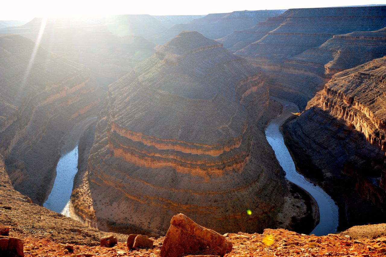
Goosenecks State Park offers a one-of-a-kind scenic view of the meandering San Juan River and the deep canyon painstakingly cut by the river over thousands of years.


Near the viewpoint, the river makes a series of tight turns–goosenecks–which give the park its name.


The viewpoint is located about 1'000 feet above the river and offers a simultaneous view of three of the San Juan River goosenecks. However, even my wide-angle lens wasn't able to fit all of them in one photo. So I'm leaving this to your imagination, or encourage you to visit Goosenecks State Park yourself.


There are no hiking trails in the park and its sole purpose of existence seem to be to provide the views of the river, yet it's worth seeing at least once in your life.


However, if you go there, learn from my mistake and visit the park in the morning or during the midday, as in the late afternoon the sun shines directly above the goosenecks, making photography almost impossible.