Showing posts with label Arizona. Show all posts

Thursday, January 10, 2013

Scenic Drive through Monument Valley Navajo Tribal Park

I've been to Monument Valley Navajo Tribal Park twice: once in summer and once in winter. Contrary to all the other places in the South-West–which I find prettier and more interesting during winter–I found Monument Valley more scenic during summer.

Monument Valley in Summer


I think there are two reasons for that. First, Monument Valley doesn't get enough snow during winter and, therefore, it isn't uniformly covered by it. To me, the patches of snow make the Valley appear more "messy" and less "monumental." Second, contrary to the summer skies, during winter skies are usually clear and cloudless, which translates to less dramatic views and less original photos.

Monument Valley in Winter


Still, we found the 17-mile Scenic Drive through the Valley very enjoyable and we would recommend it to anybody passing through that part of the world, no matter what time of the year you're there.

Scenic Drive through Monument Valley


The drive took us close to many interesting rock structures, like the two "mittens"–East and West Mitten Buttes–pictured on the photo below.

Yours truly with East and West Mitten Buttes


To some, the rock on the photo below resembles a camel and, therefore, it got named Camel Butte.

Camel Butte


Here are the Yei Bi Chei-­Navajo spiritual gods–and Totem Pole.

The Yei Bi Chei and Totem Pole


Look how small our car is compared to the nearby rocks.

My Love and his red toy in the Monument Valley


Looking back at some of the photos I took during my recent visit to the Monument Valley, makes me see how the Valley got its name. It does look quite Monumental in places.


Sunday, January 6, 2013

Fascinating Nature: American South-West in a Winter Robe

I have traveled many times through the American South-West, but this last trip was my first winter trip to the region.

To my great surprise, winter appears to be a great time to visit the South-West, possibly better than any other season. The key reason behind that is that tourists seem not to like cold weather and, subsequently, there were hardly any of them in most places we visited (with a small but notable exception of Grand Canyon, which is popular year-round).


The lack of tourists translates to a better overall experience, as witnessing the beauty and splendor of the South-West in solitude is bound to enhance your appreciation of the forces that stand behind the creation of this world's most amazing natural wonder.

Solitude encourages contemplation, introspection, as well as it enhances senses and brings closer the examiner and the subject of examination. In my case, it also led to a realization that American South-West is a Playground of Nature, a place where Nature experimented with all possible rock shapes and forms, before deciding how the rest of Earth should look like.

My second big realization was that this Nature's Playground is My Playground too. I've been very fortunate to be able to travel multiple times through South-West, with time getting to know it as well as my own backyard. This growing intimate knowledge of the region allows me to probe it further and deeper with each subsequent visit, leading to even deeper fascination and admiration for the Nature and its ways.

During the next few weeks I'm going to blog about my favorite places in the South-West, and the way they look during winter.

Here's a list of places I'll rave about:
  1. Valley of Fire State Park
  2. Monument Valley Tribal Park
  3. Gooseneck State Park
  4. Valley of Gods
  5. Canyonlands National Park, The Needless Area
  6. Newspaper Rock State Park
  7. Arches National Park
  8. Canyonlands National Park, Island in the Sky Area
  9. Dead Horse Point State Park
  10. Goblin Valley State Park
  11. Colorado National Monument
  12. Hovenweep National Monument
  13. Valley of the Ancients National Monument
  14. Mesa Verde National Park
  15. Aztec National Monument
  16. Chaco Culture National Historic Park
  17. Grand Canyon National Park, South Rim
  18. Rainbow Bridge National Monument
  19. Vermillion Cliffs National Monument
  20. Grand Staircase Escalante National Monument
  21. Paria Canyon-Vermilion Cliffs Wilderness
  22. Bryce National Park
  23. Kodachrome State Park
  24. Pink Sand Dunes State Park
  25. Zion National Park

Wednesday, November 28, 2012

Light, at the End of the Tunnel

There's hope. I've finally started to organize my photos from the last one and a half year, so the ones of you who are waiting for photos from me might get them soon in the mail.

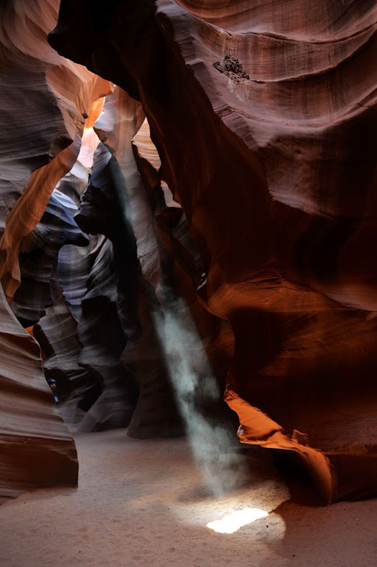
Below are some photos that I took in April this year in the Upper Antelope Canyon. I've been to the Antelope Canyon twice before, but it was the first time that I saw its famous light beams. It seems that I got lucky and manged to catch all of them.

Next aim: visit Antelope Canyon during winter.


Monday, December 13, 2010

Grand Canyon Backpacking: All Posts

Oh boy, it does feel good to finish things. Hereby I declare that I have finally completed and published all posts from my Grand Canyon Backpacking Adventure! Here they are:
  1. Grand Canyon - South Kaibab Trail
  2. Grand Canyon - Bright Angel Campground
  3. Grand Canyon - Clear Creek Trail
  4. Grand Canyon - Plateau Point Trail
  5. Grand Canyon - Bright Angel Trail

I still have around 80 unfinished posts. More or less half of them are from my 2006 trip to Africa (yes, 2006...) and the other half are from the 2009 trip to India. (Update: I've recently started working on the posts from India, and I'm planning to be posting them here throughout January till the middle of February.)

I have no idea when I will get around to working on posts from Africa - I think I would need at least a month off from work to finish them. Or at least not travel at all during the next year. The latter one is definitely not going to happen.

We are about to leave for Peru, and then also next year we plan to visit my family in Poland, Anil's family in India and hopefully also go for at least a week of holidays by ourselves (e.g. maybe on a road trip to Yellowstone NP, or along the coast all the way to Seattle). Taking a month off also does not seem likely right now, unless we will win a lottery :) (We really should start playing...)

Sunday, December 12, 2010

Grand Canyon - Plateau Point Trail

From Indian Garden we went for a short (3.2 miles/5.2 km round-trip) hike to Plateau Point, which provides absolutely fantastic views of Grand Canyon and the Colorado River. As we were staying at Indian Garden for a night, we were able to hike to Plateau Point late during the day and catch a sunset there. That made our experience even better, though I think views from Plateau Point are spectacular at any time of a day (and maybe even night, if there is a full moon).

The Plateau Point Trail is very easy and almost completely flat, so it can be hiked without any problems even during a night. We spent a good hour at Plateau Point enjoying the view of the late evening sun kissing Grand Canyon goodnight, and only started hiking back to our camp when it started to get dark. By the time we reached Indian Garden, it was pitch-dark and most other hikers were getting ready to sleep. We, however, gathered for the last meal together, which was a special treat prepared by our friend Carsten. Imagine that he made a cheesecake and carried it all the way down the canyon (and a half way up) to share with us!

Grand Canyon and the Colorado River at sunset:


Saturday, December 11, 2010

Grand Canyon - Bright Angel Trail

We decided to hike out of Grand Canyon on the Bright Angel Trail as it is the canyon's easiest trail connecting its bottom and rim. It is well maintained, at regular intervals it has taps with drinking water, and there is even a ranger station located at the trail’s halfway point.

It takes 9.6 miles (15.5 km) and 4'320 feet (1'137 m) to get from Bright Angel Campground at the bottom of the canyon to the canyon's rim. It is a distance that certainly could be covered during one day, but we decided to split it into two. We figured that it would be more enjoyable and less exhausting that way.

During the first day we hiked 4.7 miles (7.6 km) and, in a result, got 1320 feet (404 m) closer to the rim of the canyon. It took us only around 3-3.5h to cover this distance, so after setting up the camp and resting for a bit, we decided to catch a sunset at Plateau Point.

On the second day we needed to hike remaining 4.9 miles (7.9 km) and more than twice as much in the elevation change (3060 feet/933 m) as on the previous day. That was definitely the most physically exhausting day of our trip. Still, all of us did very well and we kept a good speed. (It took us 4h to cover this distance, which I think is pretty decent taking into account the elevation change and that we carried heavy backpacks.)

The hike starts with a river crossing:


The view of Grand Canyon from the trail:


Near Indian Garden we got lucky and saw several Californian Condors:


Indian Garden is located in a beautiful green valley:


On the second day the trail was much steeper:


The hikers share the trail with the mules:


The last glimpse of Grand Canyon:

Saturday, November 20, 2010

Honeymoon Road Trip

I'm very happy and proud to report that I finally managed to finish all posts describing our honeymoon adventures!

Below they are listed in the chronological order:
  1. Honeymoon
  2. Honeymoon Overview
  3. Death Valley NP - Darwin Falls Hike
  4. Death Valley NP - Mosaic Canyon Hike
  5. Death Valley NP - Mesquite Flat Sand Dunes
  6. Death Valley NP - Devil's Golfcourse
  7. Death Valley NP - Zabriskie Point
  8. Death Valley NP - Dante's View
  9. Death Valley NP - Artist's Drive and Palette
  10. Death Valley NP - Badwater Basin
  11. Snow in Death Valley
  12. Grand Canyon NP - Grandview Trail
  13. "For the record, I am dying..." - Hiking on the Grandview Trail in Grand Canyon
  14. Grand Canyon NP - Viewpoints
  15. Petrified Forrest NP - Giant Logs Trail
  16. Petrified Forrest NP - Crystal Forest
  17. Petrified Forrest NP - Newspaper Rock
  18. Petrified Forrest NP - Painted Desert
  19. Route 66
  20. On the Way to Chaco Canyon NM
  21. Rio Grande Overlook
  22. Bandalier NM
  23. Los Alamos - Bradbury Science Museum
  24. Kasha-Katuwe NM
  25. Great Sand Dunes NP - The High Dune Hike
  26. Great Sand Dunes NP - Dunes Overlook + Medano Creek Hike
  27. Great Sand Dunes NP - Sunset
  28. Zapata Falls
  29. City of Taos and Taos Pueblo
  30. Santa Fe
  31. El Santuario de Chimayo
  32. Roswell - Extraterrestrial Hwy 285 and the City
  33. Roswell - International UFO Museum and Research Center
  34. Carlsbad Caverns NP - The Natural Entrance and the Big Room
  35. Carlsbad Caverns NP - King's Palace
  36. Carlsbad Caverns NP - Bat Flight Program
  37. Carlsbad Caverns NP - Desert
  38. Guadalupe Mountains NP - McKittrick Canyon Hike
  39. Change of Plans
  40. Alamogordo - Museum of Space History
  41. White Sand Dunes
  42. Lower Antelope Canyon
  43. Lake Powell and Glen Canyon Dam
  44. Bryce - Fairyland Trail
  45. Bryce - Queen's Garden & Navajo Trail Loop
  46. Bryce NP - Viewpoints
  47. Mojave Desert
  48. Joshua Tree - Lost Palm Oasis Hike
  49. Joshua Tree - Cholla Garden
  50. Joshua Tree - Skull Rock Hike
  51. Joshua Tree - Arch Rock Hike
  52. Joshua Tree - Keys View
  53. Joshua Tree - Indian Cove Nature Walk
  54. Joshua Tree - 49 Palm Oasis Hike
  55. Santa Monica
  56. Santa Barbara

Thursday, September 30, 2010

Lake Powell and Glen Canyon Dam

I passed through Page, AZ, already twice during my travels, but so far I did not find time to stop there for longer than to take a few pictures. It is a pity as Lake Powell looks very inviting and it would definitely be cool to take a boat trip there, e.g. to the Rainbow Bridge, the world's largest natural bridge.

Glen Canyon Dam:


Habibi and Colorado River:


Damming the Colorado River caused the Glen Canyon, which lies to the north of the dam, to become flooded and has subsequently created the large reservoir called Lake Powell:


Monika and Lake Powell:

Sunday, September 26, 2010

Petrified Forest NP - Crystal Forest

I liked the Crystal Forest Trail much more than the supposedly prettier the Giant Logs Trail. As the name suggests the logs at Crystal Forest are full of crystals and, therefore, shine in the sun. All that due to the presence of silica, colored with oxides of iron and manganese, that permineralized the logs thousands of year ago...

The Crystal Forest Trail is only 0.75 mile long, it is paved and wheel-chair accessible, so it makes for a nice and easy hike. Even on an extremely hot day.

A few pics from the trail:


Petrified Forest NP - Painted Desert

Petrified wood can be found in many places in the world, so if it were only for it, the Petrified Forest NP would not be anything special. What makes this park special is its beautiful location in the Painted Desert.

As you can see on the photos below, the Painted Desert is full of badland hills, tepees, flat-topped mesas, and sculptured buttes, all in beautiful pastel colors. It unique beauty was attracting Route 66 travelers, who were happy to take a break at The Painted Desert Inn, the two-story inn located in the northern part of the park, on a high perch overlooking the nearby landscape. The Inn opened in 1924 and was nicknamed the "Stone Tree House" as it was built mostly from petrified wood.

In 1948 Painted Desert Inn was bought by the National Park Services and got converted to the Petrified Forest NP northern headquarters, featuring a shop and restaurant operated by the Fred Harvey Company (the same company that built and operated landmark hotels e.g. on the South Rim and the bottom of the Grand Canyon). Mary Colter, the company's architect and interior designer, was responsible for remodeling the Painted Desert Inn. She hired Fred Kabotie, a Hopi Indian artist, to paint murals in the lunch room and dining room. (Similarly, Mary Colter and Fred Kabotie team was responsible for the construction and murals, respectively, at the Watchtower located at the South Rim of the Grand Canyon.) I am a big fan of their work, as they always took into account the historical context of the places they were designing.

Beautiful Painted Desert:


Painted Desert Inn:


The Buffalo Dance mural in the lunch room:


The Salt Lake mural:

Petrified Forest NP - Newspaper Rock

Aside from petrified wood and other fossils, the park is also known for having thousands of prehistoric petroglyphs and pictographs. One of the most famous and easily accessible places in the park is the Newspaper Rock.

Can the raven read?


The Newspaper Rock: