Showing posts with label backpacking. Show all posts

Monday, December 13, 2010

Grand Canyon Backpacking: All Posts

Oh boy, it does feel good to finish things. Hereby I declare that I have finally completed and published all posts from my Grand Canyon Backpacking Adventure! Here they are:
  1. Grand Canyon - South Kaibab Trail
  2. Grand Canyon - Bright Angel Campground
  3. Grand Canyon - Clear Creek Trail
  4. Grand Canyon - Plateau Point Trail
  5. Grand Canyon - Bright Angel Trail

I still have around 80 unfinished posts. More or less half of them are from my 2006 trip to Africa (yes, 2006...) and the other half are from the 2009 trip to India. (Update: I've recently started working on the posts from India, and I'm planning to be posting them here throughout January till the middle of February.)

I have no idea when I will get around to working on posts from Africa - I think I would need at least a month off from work to finish them. Or at least not travel at all during the next year. The latter one is definitely not going to happen.

We are about to leave for Peru, and then also next year we plan to visit my family in Poland, Anil's family in India and hopefully also go for at least a week of holidays by ourselves (e.g. maybe on a road trip to Yellowstone NP, or along the coast all the way to Seattle). Taking a month off also does not seem likely right now, unless we will win a lottery :) (We really should start playing...)

Sunday, December 12, 2010

Grand Canyon - Plateau Point Trail

From Indian Garden we went for a short (3.2 miles/5.2 km round-trip) hike to Plateau Point, which provides absolutely fantastic views of Grand Canyon and the Colorado River. As we were staying at Indian Garden for a night, we were able to hike to Plateau Point late during the day and catch a sunset there. That made our experience even better, though I think views from Plateau Point are spectacular at any time of a day (and maybe even night, if there is a full moon).

The Plateau Point Trail is very easy and almost completely flat, so it can be hiked without any problems even during a night. We spent a good hour at Plateau Point enjoying the view of the late evening sun kissing Grand Canyon goodnight, and only started hiking back to our camp when it started to get dark. By the time we reached Indian Garden, it was pitch-dark and most other hikers were getting ready to sleep. We, however, gathered for the last meal together, which was a special treat prepared by our friend Carsten. Imagine that he made a cheesecake and carried it all the way down the canyon (and a half way up) to share with us!

Grand Canyon and the Colorado River at sunset:


Saturday, December 11, 2010

Grand Canyon - Bright Angel Trail

We decided to hike out of Grand Canyon on the Bright Angel Trail as it is the canyon's easiest trail connecting its bottom and rim. It is well maintained, at regular intervals it has taps with drinking water, and there is even a ranger station located at the trail’s halfway point.

It takes 9.6 miles (15.5 km) and 4'320 feet (1'137 m) to get from Bright Angel Campground at the bottom of the canyon to the canyon's rim. It is a distance that certainly could be covered during one day, but we decided to split it into two. We figured that it would be more enjoyable and less exhausting that way.

During the first day we hiked 4.7 miles (7.6 km) and, in a result, got 1320 feet (404 m) closer to the rim of the canyon. It took us only around 3-3.5h to cover this distance, so after setting up the camp and resting for a bit, we decided to catch a sunset at Plateau Point.

On the second day we needed to hike remaining 4.9 miles (7.9 km) and more than twice as much in the elevation change (3060 feet/933 m) as on the previous day. That was definitely the most physically exhausting day of our trip. Still, all of us did very well and we kept a good speed. (It took us 4h to cover this distance, which I think is pretty decent taking into account the elevation change and that we carried heavy backpacks.)

The hike starts with a river crossing:


The view of Grand Canyon from the trail:


Near Indian Garden we got lucky and saw several Californian Condors:


Indian Garden is located in a beautiful green valley:


On the second day the trail was much steeper:


The hikers share the trail with the mules:


The last glimpse of Grand Canyon:

Wednesday, November 3, 2010

Desolation Wilderness - Backpacking to Half Moon Lake

Yet again because of recent rain- and snowfalls, we had to change our plans, and instead backpacking in the Castle Peak area, we went backpacking in Desolation Wilderness.

In the Castle Peak area we planned to hike to Paradise Lake, but we were worried we might not reach the promised paradise because of the snow, as the highest point of that hike was nearly 9'000 feet (2'750 m). The highest point of our hike to Half Moon Lake in Desolation Wilderness was 8'200 feet (2'500 m). Also, the latter hike was several miles shorter, which made us feel more confident that we would manage to finish it.

Desolation Wilderness is right on Lake Tahoe’s southern-western edge, near South Lake Tahoe city. Its location and accessibility are likely reasons to explain its popularity. Nevertheless, it is possible to find a desolate place in the wilderness if you set out for a backpacking trip to one of the lakes located there. During the first two miles of our hike we met several other hikers, but as soon as our trail started climbing up on a set of steep switchbacks, we did not meet anybody else.

To get to our final destination, Half Moon Lake, we had to cross a rain-swollen creek, which, in the shallowest place, was around 1.5-2 feet high and 35 feet wide. Luckily, the park ranger warned us about the creek, so we carried sandals with us. When we got close to the creek, we removed our hiking shoes and socks, rolled up the trousers, put the sandals on, and walked through the freezing-cold water as fast as we could. It was actually not as bad as I had anticipated (we survived and did not loose any toes).

From the creek we had 2 more miles to the lake. We had to hurry as there were only 2h of daylight left and we still needed to set up a tent and cook a dinner. The additional challenge was that the dinner should be cooked as far away from the tent as possible, as the area is known to be inhabited by bears. Because of that we also carried a bear can with us. Before the nightfall we packed all our food, as well as all other scented items there, and we hid it under the rocks, some 150 feet away from the tent. However, it seems that the bears must have been partying in other part of the mountains that night, as we neither heard them during the night, nor we saw any bear footprints on the snow next morning.

Unexpectedly, it took us a lot of time to find a decent spot to set up a tent as the terrain around Half Moon Lake was full of both big boulders and smaller rocks. The place where we ended up setting it up had several stones that made it quite difficult for us to sleep well. Every attempt to turn was painful and led to waking up. On top of that it was extremely cold night. Even the water that we kept inside the tent froze overnight!

To survive, we had to sleep in all our clothes. I had on two pairs of winter socks, long thermal underwear, two pairs of trousers, three blouses plus two fleece jackets, gloves, and a cap that covers the whole face except for the eyes. Anil on top of all that also wore his jacket... And even with all those layers we barely felt comfortable. If it had been even a bit colder, we would have likely not been able to sleep at all.

In the morning I couldn't feel my toes, and it took them around 1h of walking to warm up. For a brief moment I even feared that I might loose some of them... This experience made me make a resolution to always carry an extra pair of gloves and 2-3 extra pairs of warm socks. You never know when you will need them.

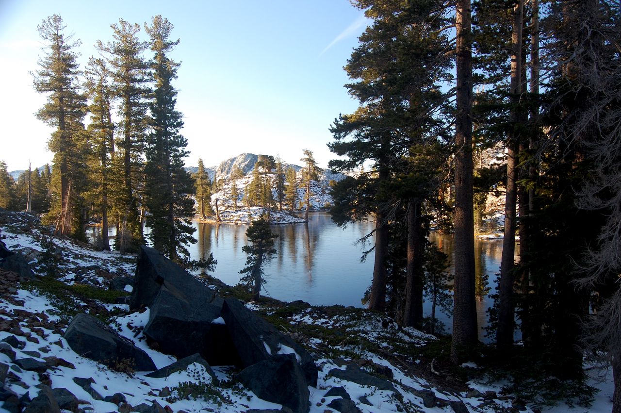
Also because of the cold I didn't take too many pictures of Half Moon Lake, which is a pity as its location is spectacular. From three sides it is surrounded by the tall granite walls, which prevent the wind from blowing there. Also, it is clear that this place does not see too many visitors and all plants and animals can live there undisturbed. It might be one of the very few unspoiled and serene, but at the same time easily accessible, places left in the US.

I hoped that on the way back to the car we would be able to go on a side trip to Mt Tallac, which at 9'735 feet should offer spectacular views of the Tahoe region. However, we were so exhausted after the cold night that our only dream was to get back to the car, and our warm home, as soon as possible.

All in all it was a great trip, and we both enjoyed it thoroughly despite the cold. The beauty of Desolation Wilderness more than compensated for this and other inconveniences.

Anil crossing one of many small creeks that formed because of recent rains and melting snow:

First two miles of the trail:


Switchbacks:


This is the creek, which caused as some trouble to cross:

You have to admit that it looks a bit ridiculous to be wearing sandals and standing in the snow:

I am freezing in the tent...

Half Moon Lake:


Ice on the trail:


Saturday, September 25, 2010

Grand Canyon - Clear Creek Trail

One of the reasons we decided to go backpacking vs day hiking in the Grand Canyon was that we wanted to fully appreciate its beauty and grandeur and, therefore, we did not want to rush through it. That's why we decided to spend two nights at the Bright Angel Campground. It allowed us to have a full day to explore the bottom of the canyon, which we used to go hiking on the Clear Creek Trail.

The Clear Creek Trail is very beautiful and offers great views of the Colorado river, as well as of the lower part of the South Kaibab Trail that we hiked the day before:


Hiking on the Clear Creek Trail:


The six brave hikers: Anne-L, Sebastian, Anne-K, Carsten and his gf, and I:


The collard lizard that we met on our way:


And here is an amazing fossil that Anne-K found:

Saturday, July 4, 2009

Grand Canyon - Bright Angel Campground

The campground at the bottom of the Grand Canyon is located alongside the Bright Angel Creek. It has 31 sites, all of which need to be reserved up to 4 months in advance through the Grand Canyon's Backcountry Permit Office. All sites are very pretty and for most of a day shaded, which is very important taking into account high temperatures that one can experience in the canyon.

If you do not feel like camping, you can also stay at the Phantom Ranch, which is located just few hundred meters away from the campground. But, honestly, why would you deprive yourself of the pleasure of caring 30+ lbs on your back up and down the canyon? ;)

Even if you are not staying at the Phantom Ranch you can still take advantage of the restaurant located there and reward yourself with a cold beer, lemonade or a glass of wine. Admittedly, it does feel awesome to drink wine at the bottom of the canyon...

In between the ranch and the campground, there is also a rangers' station, which is really cool as during afternoons and evenings rangers usually give talks on various interesting subjects like: canyon's geology, history of the trails leading to the canyon, or on California condors. We went for several of these talks and we always found them both entertaining and informative.

Bright Angel Creek as seen from our campsite:


Monday, April 20, 2009

Grand Canyon - South Kaibab Trail

We decided to hike down the South Kaibab Trail because there is no water on this trail (as opposed to the Bright Angel Trail on which we hiked out), and we figured we would need more water on our way up than on our way down.

The trailheads for the South Kaibab and Bright Angel trails are pretty far apart from each other, so we decided to park our car next to the later one and take the "Backpackers Express" shuttle to the South Kaibab trailhead located near Yaki Point. The South Kaibab Trail is 6.3 miles (10.1 km) long. Over this distance it drops 4,860 ft (1480 m), which makes it pretty steep. All of us could feel it in our knees when we were making last switchbacks in the Inner Gorge, just before the trail met with the Kaibab Suspension Bridge on which we crossed the Colorado River to get to Phantom Ranch and Bright Angel Campground.

It took as "only" 4 hours to hike all the way down to the bottom of the canyon, more or less as much as we had predicted it would take. So we had thought that after setting the campsite we would still be able to go for at least a short hike, but we ended up being so exhausted that we skipped that plan and spent the remaining of the afternoon relaxing and chilling in the shade.

On the way down the canyon, view to O'Neill Butte (on the left) from Cedar Ridge Point:


The very first glimpse of the Colorado River, just after passing the Tipoff:


The first views of the Bright Angel Creek Oasis:


The Suspension Bridge:


Crossing the Colorado River:

Backpacking in Grand Canyon

In the middle of March I went hiking in Grand Canyon with a group of friends that I know from my PhD program in Dresden, Germany. To be able to camp below the rim of the canyon, we had to apply to the Grand Canyon Backcountry Information Center for a permit four months prior to the trip. Apparently, there are three times as many applications as permits, so I guess we should consider ourselves lucky to have managed to get one of them.

Our trip started on Tuesday, 17th of March, at the San Francisco airport. From there we flew to Phoenix, AZ, which is located only 4-hours away from Grand Canyon. That meant that we still had a bit of extra time, so we stopped at Sedona Red Rock, to which I dedicated a separate post. Also on on our way back from the canyon to Phoenix we had some free time, so we visited several other parks: Walnut Canyon NM, Montezuma Castle NM, Montezuma Well, Sunset Crater Volcano NM and Wupatki NM.

As for the itinerary of our Grand Canyon hike we took one day to hike (on the South Kaibab Trail) to the bottom of the canyon, where we spent two nights at Bright Angel Campground and then we took two days to hike out (on the Bright Angel Trail). The photos and detailed description of our hike can be found in the following posts:
  1. Grand Canyon - South Kaibab Trail
  2. Grand Canyon - Bright Angel Campground
  3. Grand Canyon - Clear Creek Trail
  4. Grand Canyon - Plateau Point Trail
  5. Grand Canyon - Bright Angel Trail

My hiking companions, from left to right: Anne-K, Carsten, his gf, Sebastian, Anne-L, I: