Showing posts with label Africa 2006. Show all posts

Tuesday, March 4, 2008

30: rock engravings at Twyfelfontain

Twyfelfontein is one of the biggest and most important rock-art concentrations in Africa. The name means ''Doubtful fountain'' and it was given to this site by a local farmer who doubted that a spring which existed in the area could support cattle for a long enough time.

There are approximately 2 500 engravings around Twyfelfontein. They belong to several different rock-art styles, the most popular ones being the iconic style which depicts animals and their spoor; and the geometric style, which is characterized by abstract figures like ovals, circles, and all sorts of curving and wandering lines. It is unknown when and why these paintings/engraving were maid, but there is evidence that area was occupied as early as 6 000 years ago. It is also hypothesized that the engravings were part of the people's spiritual ceremony and were created by shamans while in a state of trance to represent their dreams = prophecies.

Soft red and yellow sandstones of Twyfelfontein provide an easy base for rock engraving, but are also susceptible to erosion:


Giraffes were supposed to symbolize presence of the nearby water source:


Iconic Twyfelfontain engraving - "Dancing lion":


Close up of dancing lion:


Other animal motifs:


Saturday, February 23, 2008

31: petrified forest

From Twyfelfontein we drove in the direction of the Petrified Forest, which is located in the heart of Damaraland, 45km away from Khorixas. At this site there are trunks of 280 million years old fossilized trees belonging to the Cordaites family (a gymnospermopsida, an ancient ancestor of today's ferns and conifers).

Tourists are not allowed to walk within the main part of petrified forest by themselves, so to be able to get to the bigger pieces of trees we needed to hire a guide. Of course our guide was as useless as all other guides that we ever had in Africa and was not able to answer almost any of our questions. She was not even able to explain to us properly how this particular petrified forest was formed (if you want to know that go here).

Still, we did not regret stopping there, as keeping in your hand a piece of petrified wood is a very interesting experience. Those pieces are so dense, and therefore heavy, that it is difficult to believe that they are not regular stones. Moreover, many of these "wood-stones" have beautiful patterns, which were formed as a result of the presence of minerals giving them all possible colors.

Gecko warming up in the sun on pieces of petrified wood:


Minerals trapped within the trunk give it rich and varied colors:


The biggest of the trees found on this site reach over 30 meters:

29: Organ Pipes

After spending three days admiring rock paintings on Brandberg we started heading north to Twyfelfontein to investigate local rock engravings. On the way there we made several short stops. One of them was at The Valley of The Organ Pipes.

The Organ Pipes is the name given to the rock formation consisting of hundreds of tall angular columns of dolorite. This formation is thought to have formed about 120 millions years ago when the ancient continent of Gondwanaland was breaking up into todays Africa and South America (more info here).

Roads in Namibia are very well maintained and there is hardly any traffic on them:


Our car:


Surprisingly green Ugab River Valley:


Ever-changing landscape with more and more interesting rock formations:


Colorful Organ Pipes:


African Star-Chestnut Tree clinging to the rocks:

28: Burnt Mountain

After visiting The Organ Pipes, we drove few kilometers further east to see the Burnt Mountain. It was formed around the same time as The Organ Pipes as a result of volcanic activity associated with separation of Gondwanaland into Africa and South America (more info here).

Seen in the late afternoon light The Burnt Mountain glows with a startling rainbow of colors, almost as if it would be on fire:


After visiting the mountain we stopped for a night at Aba-Huab Community Campsite, from where we observed the sun setting down above the Huab River and the moon rising above nearby mountains:


On the picnic table next to our tent I drew this beautiful zebra :). I hope it will still be there in a few years...

Friday, February 22, 2008

34: The Epupa waterfalls

Northern-western part of Namibia is known as Kaokoland and it is home to the Herero and Himba people. In the north, the Kunene River with its impressive system of waterfalls and cataracts separates it from Angola. The biggest of the Kunene River (and Namibia's) waterfalls is called "Epupa", which in local Herero and Himba language means "falling water". The Epupa falls might not seem impressive in size (they are only 35m), but you should remember that they occur in an extremely arid region. If you take that into account, they are actually pretty spectacular.

The Kunene River separates Namibia (located on the south rim of the river) from Angola (located on the north rim of the river):


The Epupa falls:


One of many baobabs balancing on rocks above the chasm:


At Epupa the river widens to accommodate a few small islands and to form its own little ecosystem, which dominant feature is presence of Makalani palms:


Not more than 30 meters away from the river the land reverts to typical Kaokoveld's semi-desert:

27: Namibian road signs

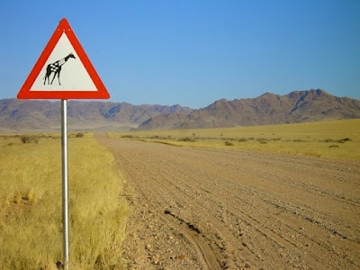
Some of the Namibian road signs were so interesting that I decided to photograph them. Below are few of my favorites.

Be aware of elephants!


Be aware of Kudus!


Yes, we also have cows:


And they often block the road:


In Swakopmund: do not drown your keys in the cocktail ;)


Be aware of oryxes:


And zebras:


And giraffes:


But most importantly, do not drive into the ocean...

Saturday, February 9, 2008

47: Moon landscape

One of the things that we did during our stay in Swakopmund was to take "The Welwitschia Plains drive" which is a self-guided car drive through part of the Namib Naukluft Park that takes around four hours to complete. To get a permit for driving your car within the park (and to get the description of the numbered beacons that you will see along your way) you have to visit Namibia Wildlife Resorts office in Swakopmund.

Part of The Welwitschia Drive goes through "Moon Landscape", which is a spectacular geological structure formed by the Swakop river millions of years ago as waters of the river were cutting through the softer surface deposits:


I changed those two pictures into black-and-white ones, as I thought that it makes the valley look even more dramatic. For comparison, here is one photo in natural colors:


At a first glance it would seem that the Namib desert is a dry and barren region, but when you look more carefully you will notice that the ground and stones are covered with lichens. Lichens depend for their survival on the mist that moves in from the sea over the desert at night and in the early morning. Because of the Namib's exceptionally misty nights, the lichen fields here are more extensive than anywhere else in the world. Some of them look like fragments of dead plant material or soil: they are gray/black and they lie loose on the surface. However, if you place them in water they will unfold and change color.

Here Jochen is experimenting with water and lichens:

46: salt factory

Just few kilometers north of Swakopmund is Cape Cross Salt Pan, which Jochen and I visited on one of the afternoons. This particular salt mine produces approximately 120 000 tons of salt per annum! Actually, the salt mines are not very impressive by themselves, but the salt pans are as they come in variety of colors.

Salt cones:


Salt pans:


Friday, February 8, 2008

Tropic of Capricorn

As BBC features today an article about Tropic of Capricorn, I decided that it is a sign for me to post my photo of the road sign which marks its position in Namibia.

However, according to the BBC article, Tropic of Capricorn position can not be marked with 100% precision as apparently it moves up to 15 meters a year over a 40,000 year cycle...

Thursday, February 7, 2008

23: Windhoek

Windhoek is the biggest city and at the same time the capital of Namibia. Still, it feels very provincial even though around 230'000 people live there (which is more than 10% of whole Namibian population!). The city is very clean and well organized, which makes it very atypical for Africa (or even Namibia). All buildings in the city seem to be freshly renovated, but their architectural style strongly resembles the one of the German colonial era (which is probably not surprising as Namibia used to be a German colony).

In the center of Windhoek (on Post Street Mall) you can find a very impressive "Gibeon Meteorite Fountain", which is build from 33 meteorites ranging in weight from 195kg to 555kg. Gibeon is the name of the Namibian village, where both the biggest recorded meteorite and the most extensive meteorite shower on earth occurred (link).

Here are few photos of Windhoek's Gibeon Meteorite Fountain: