Showing posts with label Colorado. Show all posts

Sunday, January 6, 2013

Fascinating Nature: American South-West in a Winter Robe

I have traveled many times through the American South-West, but this last trip was my first winter trip to the region.

To my great surprise, winter appears to be a great time to visit the South-West, possibly better than any other season. The key reason behind that is that tourists seem not to like cold weather and, subsequently, there were hardly any of them in most places we visited (with a small but notable exception of Grand Canyon, which is popular year-round).


The lack of tourists translates to a better overall experience, as witnessing the beauty and splendor of the South-West in solitude is bound to enhance your appreciation of the forces that stand behind the creation of this world's most amazing natural wonder.

Solitude encourages contemplation, introspection, as well as it enhances senses and brings closer the examiner and the subject of examination. In my case, it also led to a realization that American South-West is a Playground of Nature, a place where Nature experimented with all possible rock shapes and forms, before deciding how the rest of Earth should look like.

My second big realization was that this Nature's Playground is My Playground too. I've been very fortunate to be able to travel multiple times through South-West, with time getting to know it as well as my own backyard. This growing intimate knowledge of the region allows me to probe it further and deeper with each subsequent visit, leading to even deeper fascination and admiration for the Nature and its ways.

During the next few weeks I'm going to blog about my favorite places in the South-West, and the way they look during winter.

Here's a list of places I'll rave about:
  1. Valley of Fire State Park
  2. Monument Valley Tribal Park
  3. Gooseneck State Park
  4. Valley of Gods
  5. Canyonlands National Park, The Needless Area
  6. Newspaper Rock State Park
  7. Arches National Park
  8. Canyonlands National Park, Island in the Sky Area
  9. Dead Horse Point State Park
  10. Goblin Valley State Park
  11. Colorado National Monument
  12. Hovenweep National Monument
  13. Valley of the Ancients National Monument
  14. Mesa Verde National Park
  15. Aztec National Monument
  16. Chaco Culture National Historic Park
  17. Grand Canyon National Park, South Rim
  18. Rainbow Bridge National Monument
  19. Vermillion Cliffs National Monument
  20. Grand Staircase Escalante National Monument
  21. Paria Canyon-Vermilion Cliffs Wilderness
  22. Bryce National Park
  23. Kodachrome State Park
  24. Pink Sand Dunes State Park
  25. Zion National Park

Friday, December 3, 2010

Road Trip 2008: Mesa Verde

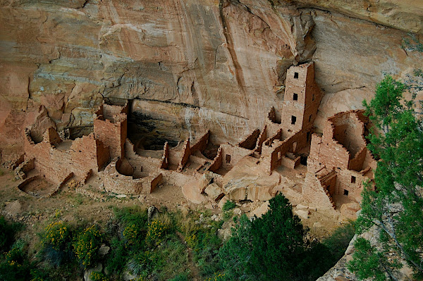
In Canyon de Chelly a park ranger recommended that we should visit Mesa Verde NP. She told us that of all parks in the four corners area, Mesa Verde NP has the most spectacular and best-preserved (and at the same time easily accessible) cliff dwellings. She was definitely right and I am very glad that we listened to her and decided to spend several days in the park.

Mesa Verde NP (green table in Spanish) protects over 4'000 archeological sites, including 600 cliff dwellings. It was inhabited by the Ancestral Pueblo people for over 700 years, from A.D. 550 to A.D. 1300. For the first six centuries, the Puebloans primarily lived on the mesa tops and only during the final 75 to 100 years they constructed and lived in the cliff dwellings for which Mesa Verde is now famous.

During the summer season, the park offers ranger-guided tours to three cliff dwellings: Cliff Palace, Balcony House and Long House. Several other dwellings (of which the most interesting are Spruce Tree House and Step House) can be visited on self-guided tours. There are also many hiking trails within the park.

Even though we spent two full days (and three nights) in the park, we only had enough time to go on one short hike (on Petroglyph Point Trail) and visit 6 cliff dwellings (the five mentioned above plus Square Tower House).

To visit Cliff Palace (as well as Balcony House and Long House) you will first need to go IN PERSON to the Far View Visitor Center to purchase a tour ticket. Cliff Palace is Mesa Verde’s largest cliff dwelling and also the one that is most popular with the visitors:


The only hike that we did in the park was 2.4 miles long (round trip) hike to Petroglyph Point:


Spruce Tree House is the park's best-preserved cliff dwelling. It can be visited on a self-guided tour. The 0.5 mile long tour takes around 1h unless you meet a chatty ranger - then it can be much longer :) On our way back we were lucky to see a rainbow forming above Spruce Tree House:


Long House can be visited on 0.75 mile, 90-minute long, ranger-guided tour that involves climbing two 15ft (5m) ladders. The tour begins with a tram ride at the Wetherill Mesa information point, 12 miles (19km) away from the Visitor Center:


Step House is also located on the Wetherill Mesa. It can be reached by hiking 0.75 miles:


Inside the kiva:


Burnt trees on the Wetherill Mesa:


View from the Chapin Mesa in direction of La Plata Mountains:


The one-hour guided tour to Balcony House is the most "adventurous" of all the tours offered in the park, and therefore, it is less popular than others. It involves climbing several ladders and crawling through a tunnel. We thought that it was funny that the Visitor Center had a model of the tunnel, so that people could decide if they wanted to crawl through it, or not. (Its second, maybe more important purpose, was to discourage fatter people from going on the tour.)


Agnieszka entering the tunnel. You can imagine how somebody bigger or less fit would have problem crawling through it:


Square Tower House:


A few tips:
  1. Driving through the park is slow! The roads leading through it are narrow, have sharp curves and steep grades.
  2. The campground in the park is huge (it has 400 sites). So I am pretty sure that you can just show up there and get a site without any problem.
  3. The elevations in the park range from 6,900 feet to 8,572 feet, so it can get pretty cold there, especially during the night.
  4. The Wetherill Mesa road is closed during the winter, so it is better to visit the park during the summer.

Saturday, November 20, 2010

Honeymoon Road Trip

I'm very happy and proud to report that I finally managed to finish all posts describing our honeymoon adventures!

Below they are listed in the chronological order:
  1. Honeymoon
  2. Honeymoon Overview
  3. Death Valley NP - Darwin Falls Hike
  4. Death Valley NP - Mosaic Canyon Hike
  5. Death Valley NP - Mesquite Flat Sand Dunes
  6. Death Valley NP - Devil's Golfcourse
  7. Death Valley NP - Zabriskie Point
  8. Death Valley NP - Dante's View
  9. Death Valley NP - Artist's Drive and Palette
  10. Death Valley NP - Badwater Basin
  11. Snow in Death Valley
  12. Grand Canyon NP - Grandview Trail
  13. "For the record, I am dying..." - Hiking on the Grandview Trail in Grand Canyon
  14. Grand Canyon NP - Viewpoints
  15. Petrified Forrest NP - Giant Logs Trail
  16. Petrified Forrest NP - Crystal Forest
  17. Petrified Forrest NP - Newspaper Rock
  18. Petrified Forrest NP - Painted Desert
  19. Route 66
  20. On the Way to Chaco Canyon NM
  21. Rio Grande Overlook
  22. Bandalier NM
  23. Los Alamos - Bradbury Science Museum
  24. Kasha-Katuwe NM
  25. Great Sand Dunes NP - The High Dune Hike
  26. Great Sand Dunes NP - Dunes Overlook + Medano Creek Hike
  27. Great Sand Dunes NP - Sunset
  28. Zapata Falls
  29. City of Taos and Taos Pueblo
  30. Santa Fe
  31. El Santuario de Chimayo
  32. Roswell - Extraterrestrial Hwy 285 and the City
  33. Roswell - International UFO Museum and Research Center
  34. Carlsbad Caverns NP - The Natural Entrance and the Big Room
  35. Carlsbad Caverns NP - King's Palace
  36. Carlsbad Caverns NP - Bat Flight Program
  37. Carlsbad Caverns NP - Desert
  38. Guadalupe Mountains NP - McKittrick Canyon Hike
  39. Change of Plans
  40. Alamogordo - Museum of Space History
  41. White Sand Dunes
  42. Lower Antelope Canyon
  43. Lake Powell and Glen Canyon Dam
  44. Bryce - Fairyland Trail
  45. Bryce - Queen's Garden & Navajo Trail Loop
  46. Bryce NP - Viewpoints
  47. Mojave Desert
  48. Joshua Tree - Lost Palm Oasis Hike
  49. Joshua Tree - Cholla Garden
  50. Joshua Tree - Skull Rock Hike
  51. Joshua Tree - Arch Rock Hike
  52. Joshua Tree - Keys View
  53. Joshua Tree - Indian Cove Nature Walk
  54. Joshua Tree - 49 Palm Oasis Hike
  55. Santa Monica
  56. Santa Barbara

Sunday, October 10, 2010

Great Sand Dunes NP - Dunes Overlook + Medano Creek hike

On the second day of our stay in the Great Sand Dunes NP we went for a hike to the Dunes Overlook in the Sangre de Cristo Mountains. We parked our car at the Pinyon Flats campground and from there we took the Dunes Overlook Trail to the viewpoint from which there were great views of the dunes and also nearby mountains.

Most hikers take the same route back to their car, but we decided to extend our hike and turn it into a 6-mile loop. To do that first we took the Sand Ramp Trail to the "Point of No Return". There we cut across the shrub field to the Medano Creek, and we hiked back to our car along (or rather in) the creek. It was a very pleasant hike that I would strongly recommend to anybody. Views were great all along our way, and hiking in the creek was lots of fun!

From the Dunes Overlook we could see dunes that we hiked a day earlier, as well as the Medano Creek in which we played:


During our hike we encountered lots of deers, seemingly surprised to see any human beings there:


We also saw some nice blooming cacti:


At the Point of No Return we started cutting our way to the Medano Creek:


And then we hiked back to the car in the creek:


This little bird was guarding our car while we were away:


Practical info:
The campground in the park is small and fills up quickly (especially on the weekend). Half of the sites can be booked online (at the NPS booking site), and the other half are "first-come, first-served". We tried to get one of the latter, but we were too late for that. Luckily, there is a private campground just before the park's entrance that has lots of camping spaces. You would have to have a really bad luck not to get a spot there even if you arrive late in the park. This campground also has warm showers, so in a way it is even better than the park's campground.

Other posts about the Great Sand Dunes NP.

Thursday, October 7, 2010

Great Sand Dunes NP - The High Dune hike

One of the highlights of our honeymoon was a visit to the Great Sand Dunes NP. Even though I had high expectations before going to this park, it still managed to exceed them!

You have to agree that seeing dunes and snow-capped mountains at the same location sounds awesome. Now add to that a creek that has waves and you get a full picture of how amazing the Great Sand Dunes NP is. It is like being on the beach and in the mountains at the same time. I guess that's why the park is so popular with families with small kids.

Water in the creek is usually pretty warm, even during winter, as the creek is shallow and, therefore, sun can warm it up quickly. Kids and adults alike love to splash in the stream as it has waves created by mounds of sand that form and fall in the creek bed. That creates water surges, similar to the action of waves at a beach. Beware that creek is a seasonal phenomenon and might be non-existent during warm summer months.

Kids, dogs, adults - everybody loves to play in the Medano Creek:


Playing in the dunes is also lots of fun!


Here I am rolling down the dune:


And here is Anil sliding down on his ass... :)


After splashing for a bit in the creek we went for a hike to "The High Dune" (198 m/650 ft), which is actually not the highest dune in the park. It is called "high" as it appears the highest from the parking lot...


Hiking in the sand is hard, but the views are so great that it is worth the effort:


After around 1.5h we made it to the top of the dune:


Going down was much faster as we could slide, roll or run down :)


A word of advice: If you go hiking in the dunefiled, wear closed shoes as sand can get unbearably hot!

Other posts about the Great Sand Dunes NP.

Great Sand Dunes NP - sunset

The weather got pretty bad on the second day of our stay at the Grand Sand Dunes NP, and because of that we were almost ready to leave the park a day earlier. But then the park is so beautiful that we decided to stay there despite the approaching storm.

Hiking in the dunes during the thunderstorm is dangerous, so instead we went for a ride. We got rewarded with this beautiful double rainbow:


After a ride we went to watch sunset over dunes. Unfortunately, there were so many clouds that we could not see the sun:


Instead we saw a big group of deer eating dinner:


The views of the dunes from our campground were also amazing:


Other posts about the Great Sand Dunes NP.

Zapata Falls

Zapata Falls are located in the San Luis Valley, just a few miles south of the Great Sand Dunes National Park entrance. So on one afternoon we went for a short hike there (1 mile round trip). Unfortunately, we did not manage to see the falls.

To see them we would need to navigate our way through the creek, and we decided against it as there was so much water in the creek that it looked dangerous to do it. Also, it was a rather cold day and we only had hiking shoes with us...

The creek:


Even though we did not manage to get to the falls, it was still worth going there as the views from the parking lot near the trailhead were great:

Sunday, January 4, 2009

Road Trip 2008: Silverton

Agnieszka wanted to see a typical "Western" town. Upon recommendation of Mike I suggested visiting Silverton, a small town in Colorado that used to be a silver mining camp. What makes Silverton even more attractive to tourists is that it can be reached by a narrow gauge railroad that originates in Durango.

The line between Durango and Silverton was constructed in 1882. Initially it was used to to haul silver and gold ore from the San Juan Mountains, but soon it started to be used by tourists as well. Even though the distance between Durango and Silverton is only 72km, it takes the train 3.5h to reach its destinations. That could seem as a lot, but actually it isn't. The rail tracks wind through such spectacular and breathtaking scenery that one wishes the trip would never end. Moreover, the train is pulled by a coal-fired, steam-powered locomotive that makes whistle sounds and produces a lot of exhaust steam, which is also a lot of fun to watch. We truly enjoyed this trip, which almost became trip in time for us. In Silverton we visited "Olde Tyme Portraits" were we had photos of ourselves taken in original 19th century outfits of ladies of dubious reputation...

Here I am standing on the platform in Durango in front of the steam engine of the narrow-gauge Durango-Silverton train:


Our train going up the mountains to Silverton:


Inside the train (we choose open compartment to have better views):


The train crosses Animas River four times in each direction:


Old Thyme Portraits in Siverton:


Agnieszka trying to ride an old type of bicycle:


Few other buildings in Silverton:


On the way back to Durango:


Durango: