Showing posts with label Grand Circle 2008. Show all posts

Tuesday, December 7, 2010

Roadtrip 2008: Peek-A-Boo Trail in Bryce NP

On the second day of our stay in Bryce NP we went for a 7-mile long hike into the canyon. We started the hike at Bryce Point with the Peek-A-Boo Trail, which drops quickly to the canyon floor and is not heavily used neither by hikers nor mules. Because of those two reasons it is my favorite hike in Bryce.

If you want to make it even better, I would recommend combining it with the spectacular Queens Garden Trail, as we did.

A few pictures from the hike:


Sunday, December 5, 2010

Road Trip 2008: Bryce NP

Bryce NP was the last national park that Agnieszka and I visited during our two week-long road trip through the Southwest in 2008. I had been to Bryce already in 2006, but for Agnieszka it was the first time. She was so immensely impressed with it that she said that she was glad it was the very last place we visited, as all other parks would seem unimpressive compared to it.

The first thing that we did in the park was to go for a drive to Rainbow Point (18 miles one way). There are 13 viewpoints along the road and we stopped at all of them. I think Rainbow and Bryce Points offered the best views, but the photos below should help you judge that for yourself.

Rainbow Point:


Natural Bridge


Bryce Point


Sunrise Point

Friday, December 3, 2010

Road Trip 2008: Mesa Verde

In Canyon de Chelly a park ranger recommended that we should visit Mesa Verde NP. She told us that of all parks in the four corners area, Mesa Verde NP has the most spectacular and best-preserved (and at the same time easily accessible) cliff dwellings. She was definitely right and I am very glad that we listened to her and decided to spend several days in the park.

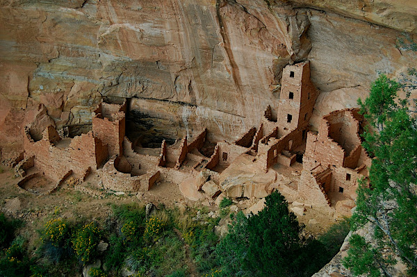
Mesa Verde NP (green table in Spanish) protects over 4'000 archeological sites, including 600 cliff dwellings. It was inhabited by the Ancestral Pueblo people for over 700 years, from A.D. 550 to A.D. 1300. For the first six centuries, the Puebloans primarily lived on the mesa tops and only during the final 75 to 100 years they constructed and lived in the cliff dwellings for which Mesa Verde is now famous.

During the summer season, the park offers ranger-guided tours to three cliff dwellings: Cliff Palace, Balcony House and Long House. Several other dwellings (of which the most interesting are Spruce Tree House and Step House) can be visited on self-guided tours. There are also many hiking trails within the park.

Even though we spent two full days (and three nights) in the park, we only had enough time to go on one short hike (on Petroglyph Point Trail) and visit 6 cliff dwellings (the five mentioned above plus Square Tower House).

To visit Cliff Palace (as well as Balcony House and Long House) you will first need to go IN PERSON to the Far View Visitor Center to purchase a tour ticket. Cliff Palace is Mesa Verde’s largest cliff dwelling and also the one that is most popular with the visitors:


The only hike that we did in the park was 2.4 miles long (round trip) hike to Petroglyph Point:


Spruce Tree House is the park's best-preserved cliff dwelling. It can be visited on a self-guided tour. The 0.5 mile long tour takes around 1h unless you meet a chatty ranger - then it can be much longer :) On our way back we were lucky to see a rainbow forming above Spruce Tree House:


Long House can be visited on 0.75 mile, 90-minute long, ranger-guided tour that involves climbing two 15ft (5m) ladders. The tour begins with a tram ride at the Wetherill Mesa information point, 12 miles (19km) away from the Visitor Center:


Step House is also located on the Wetherill Mesa. It can be reached by hiking 0.75 miles:


Inside the kiva:


Burnt trees on the Wetherill Mesa:


View from the Chapin Mesa in direction of La Plata Mountains:


The one-hour guided tour to Balcony House is the most "adventurous" of all the tours offered in the park, and therefore, it is less popular than others. It involves climbing several ladders and crawling through a tunnel. We thought that it was funny that the Visitor Center had a model of the tunnel, so that people could decide if they wanted to crawl through it, or not. (Its second, maybe more important purpose, was to discourage fatter people from going on the tour.)


Agnieszka entering the tunnel. You can imagine how somebody bigger or less fit would have problem crawling through it:


Square Tower House:

A few tips:
  1. Driving through the park is slow! The roads leading through it are narrow, have sharp curves and steep grades.
  2. The campground in the park is huge (it has 400 sites). So I am pretty sure that you can just show up there and get a site without any problem.
  3. The elevations in the park range from 6,900 feet to 8,572 feet, so it can get pretty cold there, especially during the night.
  4. The Wetherill Mesa road is closed during the winter, so it is better to visit the park during the summer.

Wednesday, December 1, 2010

Road Trip 2008: Canyonlands NP

Agnieszka and I had only one day to explore Canyonlands NP and I would say that's precisely how much time you need there if you plan to visit only the main part (called Island in the Sky) of the park. However, if you would like to venture into the Needles District, you will need both more time and a four-wheel-drive (or be willing to backpack for a few days).

"Island in the Sky" is located just 30 miles away from Arches NP, so the two parks can be easily visited during the same trip. Compared with Arches, Canyonlands does not seem too impressive, at least on the surface. I am sure though that it is a much better place for backpacking than Arches.

Upheaval Dome:


Agnieszka:


Green River Overlook:


Grand View Point:


Mesa Arch:

Monday, November 29, 2010

Road Trip 2008: Arches NP

Arches NP preserves over 2000 natural sandstone arches. The most famous one is Delicate Arch, to which I dedicated a separate post. But the park is also home to many other interesting rock formations that can easily ignite imagination not only of photographers.

There is only one small campground in the park, so it fills up very quickly. As we really wanted to stay within the park, to make sure it would happen, we got to the park at around 6 am... And even though we were there so early, there were already several other people in line in front of us. Luckily, the early bird catches the worm, and so did we manage to get one of the campsites.

We spent two days and two nights in the park, which seems to be just enough to see most of it (unless you plan to go backpacking). During that time we went for two longer and several shorter hikes. Descriptions of the shorter hikes you can find below, and to the longer ones I dedicated separate posts.

The Balanced Rock Trail is a short (0.3 mile) loop hike up to, and around, the Balanced Rock. It is definitely fascinating to see this balancing act of Nature:


The trail leading to the Park Avenue area is 1 mile long (one way) and leads next to several interesting rock formations. My favorite was the rock that Agnieszka and I called "Pharoah" (I think the official name of the rock is "Queen Nefertiti"):


Park Avenue, Courthouse Towers:


Petrified Dunes, La Sal Mountains in the background:


Garden of Eden, La Sal Mountains:


The hike to North and South Window is 1 mile (1.6 km) long and takes around 40 minutes:

Saturday, November 27, 2010

Roadtrip 2008: Delicate Arch in Arches NP

Delicate Arch is the most widely recognized landmark of both Arches NP and Utah. Its delicate beauty inspired millions of amateur, as well as professional, photographers from all over the world. It was featured multiple times on magazine covers and it is also depicted on Utah license plates.

The best way to see it is to go on a 1.5 mile long (one way) hike that starts at Wolfe Ranch parking area. The hike is very pleasant even though you can not see the Arch until the very last 100 meters of the trail.

This hike is not wheel-chair accessible. But luckily, the Arch can also be seen from a viewpoint (Lower Delicate Arch Viewpoint) that is located just next to the parking lot. From there you can see the Arch at a distance of about one mile and to take a good picture of it you will need a telephoto lens and a tripod.

From the Lower Delicate Arch Viewpoint you can continue for another 0.5 mile to the Upper Delicate Arch Viewpoint, which is closer to the Arch. However, the views from there are basically the same as from the Lower Viewpoint (though the need for a tele lens and tripod disappears).

We visited the Lower and Upper Viewpoints early in the morning, but we decided to hike to the base of Delicate Arch around sunset as this is the best time to see it. For around 5 minutes the color of the Arch is changing from yellow-orange into beautiful deep warm orange-red. It's definitely worth seeing this transformation, even though, literally, you will share this experience with several hundred other hikers and/or photographers... It did feel very artificial and surreal to be waiting with so many other people for the moment that each of us wished to be intimate.

Delicate Arch, early morning, view from the Lower Delicate Arch Viewpoint:


Delicate Arch, early morning, view from the Upper Delicate Arch Viewpoint:


Our shadows on the trail to Delicate Arch:


Hundreds of amateur photographers waiting for the sunset at Delicate Arch:


Delicate Arch, 45 minutes before sunset, the warm sunset light is not quite there yet:


Delicate Arch, 25 minutes before sunset, the long-awaited 4 minutes of warm light finally arrived: