On the second day of my visit to Yosemite NP I went hiking in Hetch Hetchy Valley.
In 1932 a dam was built on the Tuolumne River flowing through the valley, creating a reservoir that until today supplies water for the San Francisco Bay Area. Already then building of the dam was highly controversial, and one of its biggest opponents was John Muir. Also today the Sierra Club continues fight to remove the dam and restore Hetch Hetchy Valley. As much as I would like to see it happen, I doubt that it will. First, an alternative water supply source has to be offered to the Bay Area inhabitants and so far I've not heard about any. Second, after hundred years under water it probably will take at least twice as much time for the valley to recover. (This, of course, is not an argument against doing it. I'm just saying that I'm not likely to see restored Hetch Hetchy Valley within my lifetime).
In Hetch Hetchy I went for a 5.4 mile hike to Wapama Falls. It is an easy hike, with not much elevation change (800ft), that takes around 2.5 hours to complete. The trail goes parallel to the shore of the reservoir, offering great views throughout, and culminates at spectacular Wapama Falls. At the base of the falls there are several wooden footbridges that can be dangerous to cross when the water is high. I was a bit worried that that part of the trail might be closed, but luckily it wasn't and I managed to get close to the falls and take a few cool shots of them.
I would strongly recommend making this small detour and visiting Hetch Hetchy during your next visit to Yosemite. It is equally beautiful as Yosemite Valley, but less crowded and more serene.
Wapama Falls, Hetch Hetchy Reservoir and a piece of O'Shaughnessy Dam:
Showing posts with label Yosemite. Show all posts
Monday, August 8, 2011
Saturday, August 6, 2011
Yosemite NP - Nevada Fall Hike
I've been to Yosemite Valley several times before and I went for many hikes there. They were all good, offering great views, good trails and many of them culminated at waterfalls making the hikes even more attractive. The only problem with all these hikes is that they are hikers' highways and no matter what time of the year or day you go there, you are bound to meet hundreds of other nature lovers.
The Nevada Fall hike was not exception to this rule. It was lovely, but very busy with hikers.
The trailhead for the hike is at Happy Isles, near the shuttle stop number 16. From there, one has to cross the road bridge on the Merced River and follow the trail on its east (true right) bank. Soon the trail becomes paved and starts ascending gently to reach the Vernal Fall footbridge from which there are fantastic views of Vernal Fall and Merced River (see the photo below). A few minutes after the bridge there is a fork in the trail. The trail to the right is the John Muir Trail, which I took to get to the Nevada Fall. The falls can also be reached by the other trail, the Mist Trail, which is shorter and steeper. As it was raining, I decided against hiking on the latter as I was worried that it would be too slippery. However, in future I'll try to make the full loop and hike to the Nevada Falls on the John Muir Trail and return back to Yosemite Valley on the Mist Trail.
The hike, depending on the route chosen, is around 6-7 miles long, ascends 1850ft, and takes around 3.5 hours to complete.
Vernal Fall and Merced River from the Vernal Fall fotbridge:
The Nevada Fall hike was not exception to this rule. It was lovely, but very busy with hikers.
The trailhead for the hike is at Happy Isles, near the shuttle stop number 16. From there, one has to cross the road bridge on the Merced River and follow the trail on its east (true right) bank. Soon the trail becomes paved and starts ascending gently to reach the Vernal Fall footbridge from which there are fantastic views of Vernal Fall and Merced River (see the photo below). A few minutes after the bridge there is a fork in the trail. The trail to the right is the John Muir Trail, which I took to get to the Nevada Fall. The falls can also be reached by the other trail, the Mist Trail, which is shorter and steeper. As it was raining, I decided against hiking on the latter as I was worried that it would be too slippery. However, in future I'll try to make the full loop and hike to the Nevada Falls on the John Muir Trail and return back to Yosemite Valley on the Mist Trail.
The hike, depending on the route chosen, is around 6-7 miles long, ascends 1850ft, and takes around 3.5 hours to complete.
Vernal Fall and Merced River from the Vernal Fall fotbridge:
Posted by
monsun
at
9:34 PM
Labels:
California,
hiking,
national park,
photos,
US,
US travel,
Yosemite
Thursday, August 4, 2011
Yosemite Valley
Memorial Weekend is one of the two worst weekends to visit Yosemite NP (the other one being 4th of July weekend). During these two weekends the park is insanely busy with tourists, which takes away from the experience. Suffice to say that the only accommodation that I could find for that weekend was more than 40 miles away from the park! (Admittedly, I only decided to visit the park and look for accommodation there 3 weeks before the trip). If you can, visit the park during any other weekend, or even better on a weekday.
As I'm extremely busy with work these days, I had no other choice but to go to Yosemite NP on the Memorial weekend, if I wanted to visit the park in the prime season to see its waterfalls. Usually they run highest in May and the rumor had it that this year all waterfalls were running even higher than usual due to the largest snowpack in 30+ years. E.g. for the Merced River drainage this year's snowpack was 199% of previous years' average. In fact there was so much water in some waterfalls that it was impossible to take photos of them! I tried to get to the bottom of Bridalveil Falls to take a picture of them, but I did not manage. They were splashing so much water that it felt like being caught in the eye of a rainstorm.
I had more luck with other falls and managed to get some pretty good shots of Yosemite, Vernal, Nevada and Wapama Falls.
Yosemite Falls:
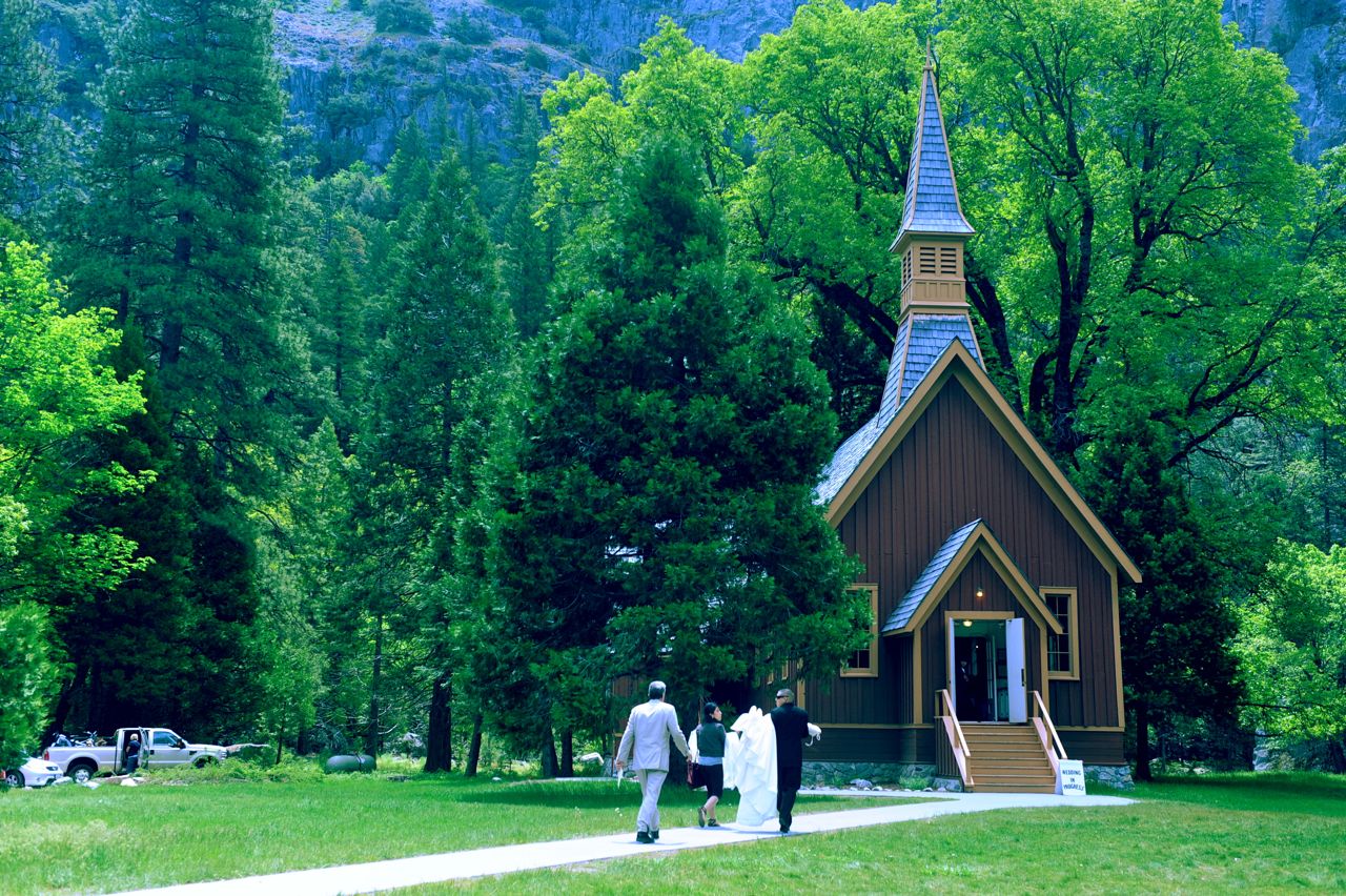
A little church in Yosemite Valley. Notice a man carrying a bridal gown:
As I'm extremely busy with work these days, I had no other choice but to go to Yosemite NP on the Memorial weekend, if I wanted to visit the park in the prime season to see its waterfalls. Usually they run highest in May and the rumor had it that this year all waterfalls were running even higher than usual due to the largest snowpack in 30+ years. E.g. for the Merced River drainage this year's snowpack was 199% of previous years' average. In fact there was so much water in some waterfalls that it was impossible to take photos of them! I tried to get to the bottom of Bridalveil Falls to take a picture of them, but I did not manage. They were splashing so much water that it felt like being caught in the eye of a rainstorm.
I had more luck with other falls and managed to get some pretty good shots of Yosemite, Vernal, Nevada and Wapama Falls.
Yosemite Falls:
A little church in Yosemite Valley. Notice a man carrying a bridal gown:
Thursday, October 29, 2009
Fall in Yosemite
I have been to Yosemite NP three times this year: first time with Anil on the Memorial Day Weekend, second time again with Anil and my parents at the end of July and third time just now, at the end of October. My very first visit to Yosemite NP was in September of 2007 with Ania and Molly: link.
Seeing the park during several different times of the year I have to conclude that the best time to visit is late fall (end of September - mid of November) as the weather is still good then and the number of tourists falls down drastically. Early spring might be a good time to visit the Yosemite Valley, but the rest of the park will most likely be not passable then yet because of the snow. If you decide to visit the park in the late fall it might be a good idea to sleep in a "heated and insulated tent" as we did it this time around, as nights get really cold. If you have a good sleeping bag then it might be still possible to sleep in your own tent.
Below are several photos taken during the last visit to Yosemite NP.
Bridalveil Falls:

Vernal Falls (much less water than at the end of July!):

Beautiful fall morning nearby our campground at Curry Village:

Upper Yosemite Fall:

Meadow:

Siesta Lake:

Half Dome and Monika (from North Dome trail):
Seeing the park during several different times of the year I have to conclude that the best time to visit is late fall (end of September - mid of November) as the weather is still good then and the number of tourists falls down drastically. Early spring might be a good time to visit the Yosemite Valley, but the rest of the park will most likely be not passable then yet because of the snow. If you decide to visit the park in the late fall it might be a good idea to sleep in a "heated and insulated tent" as we did it this time around, as nights get really cold. If you have a good sleeping bag then it might be still possible to sleep in your own tent.
Below are several photos taken during the last visit to Yosemite NP.
Bridalveil Falls:
Vernal Falls (much less water than at the end of July!):
Beautiful fall morning nearby our campground at Curry Village:
Upper Yosemite Fall:
Meadow:
Siesta Lake:
Half Dome and Monika (from North Dome trail):
Friday, July 31, 2009
Yosemite Valley & Vernal Falls hike
Visiting the Yosemite Valley on a "regular" Monday (as opposed to Memorial Weekend Sunday) was a surprisingly nice experience. The valley was still full of tourists, but at least this time we did not waste half an hour looking for a parking spot nor we needed to wait 10 minutes for a permission to cross a street...
My parents with Yosemite Valley in the background:

Bridal Veil falls, very beautiful, but difficult to photograph in the midday sun:

My parents and Half Dome:

Me happy in front of the Yosemite Falls:

Last time Anil and I visited the park, we went for the Yosemite Falls hike. This time we decided to go for the Vernal Falls hike. Not only was this hike easier, but it was also prettier than the previous one. Half the pain, twice as much fun :) If you have time for only one hike in the park and you want to see a beautiful waterfall, I would recommend choosing the Vernal Falls hike. You will not be disappointed.
On the way to the Vernal Falls:

Almost there!

Vernal Falls and rainbow:

Vernal Falls and Monika:

Anil on the way back to the valley floor:

If you look closely, you will see the Upper Yosemite Falls in this picture:
My parents with Yosemite Valley in the background:
Bridal Veil falls, very beautiful, but difficult to photograph in the midday sun:
My parents and Half Dome:
Me happy in front of the Yosemite Falls:
Last time Anil and I visited the park, we went for the Yosemite Falls hike. This time we decided to go for the Vernal Falls hike. Not only was this hike easier, but it was also prettier than the previous one. Half the pain, twice as much fun :) If you have time for only one hike in the park and you want to see a beautiful waterfall, I would recommend choosing the Vernal Falls hike. You will not be disappointed.
On the way to the Vernal Falls:
Almost there!
Vernal Falls and rainbow:

Vernal Falls and Monika:
Anil on the way back to the valley floor:
If you look closely, you will see the Upper Yosemite Falls in this picture:
Sunday, May 31, 2009
Yosemite NP
Even though I tried to avoid it at all cost, we ended up going to Yosemite NP on the Memorial Day weekend. The problem with Yosemite NP is that it is always very crowded, even more so on weekends, not to mention the wild crowds that you need to expect there on a three-day weekend. We thought that we were prepared for that. We were wrong. It was just insane - there were easily more than 30'000 cars in the Yosemite Valley and it was impossible to find a parking spot anywhere. There was not a single accommodation left (neither on the campground nor hotel) within 1.5h drive from the park. The lines (at least to the ladies' restrooms) were 20 minutes long. Wherever you went, you would soon meet another fellow human being. Yosemite Valley might be stunningly beautiful, but with all those hundreds of thousands of people moving around in it, it feels just like downtown San Francisco.
Things got slightly better when we started hiking up to the Upper Yosemite Falls (6.8mi/10.9km-long hike climbing up 2410ft/735m). These falls were the reason that we decided to go to Yosemite Valley despite knowing that it would mean meeting thousands of other people. Yosemite NP is full of waterfalls and majority of them are at their peak in the month of May. I thought it would be cool to see them since we are in this part of Sierras anyway. In particular, I was interested in Yosemite Falls, which is the highest free-leaping waterfall in North America. From the top of the upper falls to the base of the lower falls it drops the total of 2420ft/739m. The Upper Falls alone drop 1430ft/436m.
The trail to the Upper Yosemite Falls starts with four dozen steep switchbacks, which discourage majority of weekend hikers. After climbing 1000ft/305m the trail reaches Columbia Rock viewpoint that offers spectacular views of Yosemite Valley and Half Dome. Around two thirds of the hikers who made it that far, turn around and do not attempt to go farther up on another set of switchbacks. We made it all the way up, but it was not easy. After the lunch break that we had at the feet of the Upper Yosemite Falls, N. started feeling sick and was moving up at the snail speed. I almost started to have doubts that we would make it to the top of the falls, but luckily we did. He started feeling better as soon as we started going down, which would make me think that he might have an altitude sickness if we were not hiking ~4000ft/1300m higher the previous day without any problems.
Anyway, I am glad that we went for this hike. Seeing the Upper Falls from up-close was amazing, especially that we could observe the rainbow forming there for more than an hour. Also the views of Half Dome and the Valley were pretty spectacular, compensating for the lack of intimacy on the trail.
Tioga Lake, still partly frozen:


Tenaya Lake:

Beautiful Hwy 120 leading through Yosemite NP:

The view of Half Dome's back from Olmsted Point:

Glacial erratic boulder at the Olmsted Point:

Yosemite Valley and Merced River:

Yosemite Falls:

View of Half Dome from Columbia Rock viewpoint on the trail to Upper Yosemite Falls:

Rainbow at the feet of Upper Yosemite Falls:

Rainbow!

Waterfall, Half Dome and rainbow:

The view of Yosemite Valley from the top of Upper Yosemite Fall:
Things got slightly better when we started hiking up to the Upper Yosemite Falls (6.8mi/10.9km-long hike climbing up 2410ft/735m). These falls were the reason that we decided to go to Yosemite Valley despite knowing that it would mean meeting thousands of other people. Yosemite NP is full of waterfalls and majority of them are at their peak in the month of May. I thought it would be cool to see them since we are in this part of Sierras anyway. In particular, I was interested in Yosemite Falls, which is the highest free-leaping waterfall in North America. From the top of the upper falls to the base of the lower falls it drops the total of 2420ft/739m. The Upper Falls alone drop 1430ft/436m.
The trail to the Upper Yosemite Falls starts with four dozen steep switchbacks, which discourage majority of weekend hikers. After climbing 1000ft/305m the trail reaches Columbia Rock viewpoint that offers spectacular views of Yosemite Valley and Half Dome. Around two thirds of the hikers who made it that far, turn around and do not attempt to go farther up on another set of switchbacks. We made it all the way up, but it was not easy. After the lunch break that we had at the feet of the Upper Yosemite Falls, N. started feeling sick and was moving up at the snail speed. I almost started to have doubts that we would make it to the top of the falls, but luckily we did. He started feeling better as soon as we started going down, which would make me think that he might have an altitude sickness if we were not hiking ~4000ft/1300m higher the previous day without any problems.
Anyway, I am glad that we went for this hike. Seeing the Upper Falls from up-close was amazing, especially that we could observe the rainbow forming there for more than an hour. Also the views of Half Dome and the Valley were pretty spectacular, compensating for the lack of intimacy on the trail.
Tioga Lake, still partly frozen:


Tenaya Lake:

Beautiful Hwy 120 leading through Yosemite NP:

The view of Half Dome's back from Olmsted Point:

Glacial erratic boulder at the Olmsted Point:

Yosemite Valley and Merced River:

Yosemite Falls:

View of Half Dome from Columbia Rock viewpoint on the trail to Upper Yosemite Falls:

Rainbow at the feet of Upper Yosemite Falls:

Rainbow!

Waterfall, Half Dome and rainbow:

The view of Yosemite Valley from the top of Upper Yosemite Fall:
Subscribe to:
Posts (Atom)